Homely Learning visit by Ian Mackey ODA Trustee and Outreach officer)
In October 2023 we had a visit to the Offa’s Dyke Centre from Homely Learning . Emma Brown got in touch (a few times because the visit was important part of their curriculum) and we arranged a date and time. What was lovely is that she was determined the visit would be to the centre to enjoy the landscape, ambiance and the displays.
The weather had not been all that good with the recent storm Babet, and the little ones had to come from Ty Mawr, Llangorse tucked into the north of Bannau Brycheiniog (ban-aye bruch-ay-nee-og )– a beautiful landscape, so it was quite a journey and commitment by the school – thank you to them.
Overview
I met the group at the centre – kindly opened by Dave McGlade
Their visit was on a day after the last of storm Babet so they had had some heavy rainfall though luckily it was well behaved for the day.
It was a small group of pupils accompanied by 3 adults and, apparently, some pupils had levels of learning difficulty but you couldn’t tell as they were polite, cheery, engaged, fun and enthusiastic as well as incredibly intelligently switched on. I had to be careful what I talked about because they had a good understanding of the Welsh – Anglo-Saxon history and would ask great questions as well as answering some tricky ones.
The session started at 10:30 and ended at 2:00pm with a few small comfort breaks and a post-lunch play on the swings …no, not me. Luckily the weather had turned bright and sunny by then and we had taken a wander down to the Dyke section where the wonderful Anglo-Welsh bridge is.
The planned itinerary
Well, it was a good idea at the time and we got a lot done and it was good fun for all of us – but as with so many Outreach visits, some things were adapted on-the-fly because the youngsters were in-the-zone and asked interesting questions.Offa of the Mercians and his affect (with PowerPoint slides)
The seat of power …
A visit to the Dyke and the Anglo-Celtic border
…save me from these rampaging Celts
Phew – they’re on their side of the liminal border
…though this one is not so sure which way to go.
It was a lovely day all round, and as they left the youngsters were full of smiles and waves.
Emma and I even discussed a visit down to Ty Mawr (“the big house”) with a local historian to investigate the archaeology and heritage in their immediate neighbourhood. I’ll keep you updated on that either in the newsletter or the Podcast.
“Get Offa my land …”
They even got to meet ArchaeoDog
For more information on an Outreach visit, contact outreach@offasdyke.org.uk ; visit the website https://digitalskills.ittutor.training/oda/ or get in touch with the Offa’s Dyke Association
{467141:TEIICT3U};{467141:5YC7L8PQ}
harvard1
default
asc
0
659
%7B%22status%22%3A%22success%22%2C%22updateneeded%22%3Afalse%2C%22instance%22%3Afalse%2C%22meta%22%3A%7B%22request_last%22%3A1200%2C%22request_next%22%3A50%2C%22used_cache%22%3Atrue%7D%2C%22data%22%3A%5B%7B%22key%22%3A%22TIQYTUHW%22%2C%22library%22%3A%7B%22id%22%3A467141%7D%2C%22meta%22%3A%7B%22creatorSummary%22%3A%22College%22%2C%22numChildren%22%3A1%7D%2C%22bib%22%3A%22%26lt%3Bdiv%20class%3D%26quot%3Bcsl-bib-body%26quot%3B%20style%3D%26quot%3Bline-height%3A%201.35%3B%20%26quot%3B%26gt%3B%5Cn%20%20%26lt%3Bdiv%20class%3D%26quot%3Bcsl-entry%26quot%3B%26gt%3BCollege%2C%20O.%20%28no%20date%29%20%26lt%3Bi%26gt%3BIllustration%20from%20Anatomy%20%26amp%3B%20Physiology%2C%20Connexions%20Web%20site.%20http%3A%5C%2F%5C%2Fcnx.org%5C%2Fcontent%5C%2Fcol11496%5C%2F1.6%5C%2F%2C%20Jun%2019%2C%202013.%26lt%3B%5C%2Fi%26gt%3B%20Available%20at%3A%20%26lt%3Ba%20class%3D%26%23039%3Bzp-ItemURL%26%23039%3B%20href%3D%26%23039%3Bhttps%3A%5C%2F%5C%2Fcommons.wikimedia.org%5C%2Fwiki%5C%2FFile%3A2314_Boyles_Law.jpg%23%26%23039%3B%26gt%3Bhttps%3A%5C%2F%5C%2Fcommons.wikimedia.org%5C%2Fwiki%5C%2FFile%3A2314_Boyles_Law.jpg%23%26lt%3B%5C%2Fa%26gt%3B%20%28Accessed%3A%20September%2023%2C%202025%29.%26lt%3B%5C%2Fdiv%26gt%3B%5Cn%26lt%3B%5C%2Fdiv%26gt%3B%22%2C%22data%22%3A%7B%22itemType%22%3A%22artwork%22%2C%22title%22%3A%22Illustration%20from%20Anatomy%20%26%20Physiology%2C%20Connexions%20Web%20site.%20http%3A%5C%2F%5C%2Fcnx.org%5C%2Fcontent%5C%2Fcol11496%5C%2F1.6%5C%2F%2C%20Jun%2019%2C%202013.%22%2C%22creators%22%3A%5B%7B%22creatorType%22%3A%22artist%22%2C%22firstName%22%3A%22OpenStax%22%2C%22lastName%22%3A%22College%22%7D%5D%2C%22abstractNote%22%3A%22%22%2C%22artworkMedium%22%3A%22%22%2C%22artworkSize%22%3A%22%22%2C%22date%22%3A%22%22%2C%22language%22%3A%22%22%2C%22url%22%3A%22https%3A%5C%2F%5C%2Fcommons.wikimedia.org%5C%2Fwiki%5C%2FFile%3A2314_Boyles_Law.jpg%23%22%2C%22collections%22%3A%5B%5D%2C%22dateModified%22%3A%222025-09-23T13%3A32%3A40Z%22%7D%7D%2C%7B%22key%22%3A%22CYVA5ZRS%22%2C%22library%22%3A%7B%22id%22%3A467141%7D%2C%22meta%22%3A%7B%22numChildren%22%3A0%7D%2C%22bib%22%3A%22%26lt%3Bdiv%20class%3D%26quot%3Bcsl-bib-body%26quot%3B%20style%3D%26quot%3Bline-height%3A%201.35%3B%20%26quot%3B%26gt%3B%5Cn%20%20%26lt%3Bdiv%20class%3D%26quot%3Bcsl-entry%26quot%3B%26gt%3B%26lt%3Bi%26gt%3BChange%20your%20name%20by%20deed%20poll%26lt%3B%5C%2Fi%26gt%3B%20%28no%20date%29%20%26lt%3Bi%26gt%3BGOV.UK%26lt%3B%5C%2Fi%26gt%3B.%20Available%20at%3A%20%26lt%3Ba%20class%3D%26%23039%3Bzp-ItemURL%26%23039%3B%20href%3D%26%23039%3Bhttps%3A%5C%2F%5C%2Fwww.gov.uk%5C%2Fchange-name-deed-poll%26%23039%3B%26gt%3Bhttps%3A%5C%2F%5C%2Fwww.gov.uk%5C%2Fchange-name-deed-poll%26lt%3B%5C%2Fa%26gt%3B%20%28Accessed%3A%20September%2019%2C%202025%29.%26lt%3B%5C%2Fdiv%26gt%3B%5Cn%26lt%3B%5C%2Fdiv%26gt%3B%22%2C%22data%22%3A%7B%22itemType%22%3A%22webpage%22%2C%22title%22%3A%22Change%20your%20name%20by%20deed%20poll%22%2C%22creators%22%3A%5B%5D%2C%22abstractNote%22%3A%22A%20deed%20poll%20recognises%20a%20change%20of%20name%20of%20an%20adult%20or%20child%20-%20make%20your%20own%2C%20use%20official%20forms%2C%20or%20get%20one%20through%20a%20specialist%20agency%20or%20solicitor.%22%2C%22date%22%3A%22%22%2C%22url%22%3A%22https%3A%5C%2F%5C%2Fwww.gov.uk%5C%2Fchange-name-deed-poll%22%2C%22language%22%3A%22en%22%2C%22collections%22%3A%5B%22ZKVH2XQ3%22%5D%2C%22dateModified%22%3A%222025-09-19T13%3A36%3A50Z%22%7D%7D%2C%7B%22key%22%3A%22YX79TLSE%22%2C%22library%22%3A%7B%22id%22%3A467141%7D%2C%22meta%22%3A%7B%22numChildren%22%3A0%7D%2C%22bib%22%3A%22%26lt%3Bdiv%20class%3D%26quot%3Bcsl-bib-body%26quot%3B%20style%3D%26quot%3Bline-height%3A%201.35%3B%20%26quot%3B%26gt%3B%5Cn%20%20%26lt%3Bdiv%20class%3D%26quot%3Bcsl-entry%26quot%3B%26gt%3B%26lt%3Bi%26gt%3BApply%20for%20a%20Gender%20Recognition%20Certificate%26lt%3B%5C%2Fi%26gt%3B%20%28no%20date%29%20%26lt%3Bi%26gt%3BGOV.UK%26lt%3B%5C%2Fi%26gt%3B.%20Available%20at%3A%20%26lt%3Ba%20class%3D%26%23039%3Bzp-ItemURL%26%23039%3B%20href%3D%26%23039%3Bhttps%3A%5C%2F%5C%2Fwww.gov.uk%5C%2Fapply-gender-recognition-certificate%26%23039%3B%26gt%3Bhttps%3A%5C%2F%5C%2Fwww.gov.uk%5C%2Fapply-gender-recognition-certificate%26lt%3B%5C%2Fa%26gt%3B%20%28Accessed%3A%20September%2019%2C%202025%29.%26lt%3B%5C%2Fdiv%26gt%3B%5Cn%26lt%3B%5C%2Fdiv%26gt%3B%22%2C%22data%22%3A%7B%22itemType%22%3A%22webpage%22%2C%22title%22%3A%22Apply%20for%20a%20Gender%20Recognition%20Certificate%22%2C%22creators%22%3A%5B%5D%2C%22abstractNote%22%3A%22Apply%20for%20a%20Gender%20Recognition%20Certificate%20to%20legally%20change%20your%20gender.%22%2C%22date%22%3A%22%22%2C%22url%22%3A%22https%3A%5C%2F%5C%2Fwww.gov.uk%5C%2Fapply-gender-recognition-certificate%22%2C%22language%22%3A%22en%22%2C%22collections%22%3A%5B%22ZKVH2XQ3%22%5D%2C%22dateModified%22%3A%222025-09-19T13%3A36%3A41Z%22%7D%7D%2C%7B%22key%22%3A%2226YPRYR5%22%2C%22library%22%3A%7B%22id%22%3A467141%7D%2C%22meta%22%3A%7B%22numChildren%22%3A1%7D%2C%22bib%22%3A%22%26lt%3Bdiv%20class%3D%26quot%3Bcsl-bib-body%26quot%3B%20style%3D%26quot%3Bline-height%3A%201.35%3B%20%26quot%3B%26gt%3B%5Cn%20%20%26lt%3Bdiv%20class%3D%26quot%3Bcsl-entry%26quot%3B%26gt%3B%26lt%3Bi%26gt%3BCommunity%20benefits%20and%20shared%20ownership%20for%20low%20carbon%20energy%20infrastructure%3A%20working%20paper%20%28accessible%20webpage%29%26lt%3B%5C%2Fi%26gt%3B%20%28no%20date%29%20%26lt%3Bi%26gt%3BGOV.UK%26lt%3B%5C%2Fi%26gt%3B.%20Available%20at%3A%20%26lt%3Ba%20class%3D%26%23039%3Bzp-ItemURL%26%23039%3B%20href%3D%26%23039%3Bhttps%3A%5C%2F%5C%2Fwww.gov.uk%5C%2Fgovernment%5C%2Fpublications%5C%2Fcommunity-benefits-and-shared-ownership-for-low-carbon-energy-infrastructure%5C%2Fcommunity-benefits-and-shared-ownership-for-low-carbon-energy-infrastructure-working-paper-accessible-webpage%26%23039%3B%26gt%3Bhttps%3A%5C%2F%5C%2Fwww.gov.uk%5C%2Fgovernment%5C%2Fpublications%5C%2Fcommunity-benefits-and-shared-ownership-for-low-carbon-energy-infrastructure%5C%2Fcommunity-benefits-and-shared-ownership-for-low-carbon-energy-infrastructure-working-paper-accessible-webpage%26lt%3B%5C%2Fa%26gt%3B%20%28Accessed%3A%20September%2019%2C%202025%29.%26lt%3B%5C%2Fdiv%26gt%3B%5Cn%26lt%3B%5C%2Fdiv%26gt%3B%22%2C%22data%22%3A%7B%22itemType%22%3A%22webpage%22%2C%22title%22%3A%22Community%20benefits%20and%20shared%20ownership%20for%20low%20carbon%20energy%20infrastructure%3A%20working%20paper%20%28accessible%20webpage%29%22%2C%22creators%22%3A%5B%5D%2C%22abstractNote%22%3A%22%22%2C%22date%22%3A%22%22%2C%22url%22%3A%22https%3A%5C%2F%5C%2Fwww.gov.uk%5C%2Fgovernment%5C%2Fpublications%5C%2Fcommunity-benefits-and-shared-ownership-for-low-carbon-energy-infrastructure%5C%2Fcommunity-benefits-and-shared-ownership-for-low-carbon-energy-infrastructure-working-paper-accessible-webpage%22%2C%22language%22%3A%22en%22%2C%22collections%22%3A%5B%22ZKVH2XQ3%22%5D%2C%22dateModified%22%3A%222025-09-19T13%3A35%3A02Z%22%7D%7D%2C%7B%22key%22%3A%22TYNUZZJQ%22%2C%22library%22%3A%7B%22id%22%3A467141%7D%2C%22meta%22%3A%7B%22creatorSummary%22%3A%22Salkin%22%2C%22parsedDate%22%3A%222007%22%2C%22numChildren%22%3A0%7D%2C%22bib%22%3A%22%26lt%3Bdiv%20class%3D%26quot%3Bcsl-bib-body%26quot%3B%20style%3D%26quot%3Bline-height%3A%201.35%3B%20%26quot%3B%26gt%3B%5Cn%20%20%26lt%3Bdiv%20class%3D%26quot%3Bcsl-entry%26quot%3B%26gt%3BSalkin%2C%20P.%20%282007%29%20%26%23x201C%3BUnderstanding%20Community%20Benefit%20Agreements%3A%20Opportunities%20and%20Traps%20for%20Developers%2C%20Municipalities%20and%20Community%20Organizations%2C%26%23x201D%3B%20%26lt%3Bi%26gt%3BSSRN%20Electronic%20Journal%26lt%3B%5C%2Fi%26gt%3B%20%5BPreprint%5D.%20Available%20at%3A%20%26lt%3Ba%20class%3D%26%23039%3Bzp-DOIURL%26%23039%3B%20href%3D%26%23039%3Bhttps%3A%5C%2F%5C%2Fdoi.org%5C%2F10.2139%5C%2Fssrn.1025724%26%23039%3B%26gt%3Bhttps%3A%5C%2F%5C%2Fdoi.org%5C%2F10.2139%5C%2Fssrn.1025724%26lt%3B%5C%2Fa%26gt%3B.%26lt%3B%5C%2Fdiv%26gt%3B%5Cn%26lt%3B%5C%2Fdiv%26gt%3B%22%2C%22data%22%3A%7B%22itemType%22%3A%22journalArticle%22%2C%22title%22%3A%22Understanding%20Community%20Benefit%20Agreements%3A%20Opportunities%20and%20Traps%20for%20Developers%2C%20Municipalities%20and%20Community%20Organizations%22%2C%22creators%22%3A%5B%7B%22creatorType%22%3A%22author%22%2C%22firstName%22%3A%22Patricia%22%2C%22lastName%22%3A%22Salkin%22%7D%5D%2C%22abstractNote%22%3A%22%22%2C%22date%22%3A%222007%22%2C%22language%22%3A%22en%22%2C%22DOI%22%3A%2210.2139%5C%2Fssrn.1025724%22%2C%22ISSN%22%3A%221556-5068%22%2C%22url%22%3A%22http%3A%5C%2F%5C%2Fwww.ssrn.com%5C%2Fabstract%3D1025724%22%2C%22collections%22%3A%5B%22ZKVH2XQ3%22%5D%2C%22dateModified%22%3A%222025-09-19T13%3A34%3A23Z%22%7D%7D%2C%7B%22key%22%3A%22C8W5FEJY%22%2C%22library%22%3A%7B%22id%22%3A467141%7D%2C%22meta%22%3A%7B%22numChildren%22%3A0%7D%2C%22bib%22%3A%22%26lt%3Bdiv%20class%3D%26quot%3Bcsl-bib-body%26quot%3B%20style%3D%26quot%3Bline-height%3A%201.35%3B%20%26quot%3B%26gt%3B%5Cn%20%20%26lt%3Bdiv%20class%3D%26quot%3Bcsl-entry%26quot%3B%26gt%3B%26lt%3Bi%26gt%3BCommunity%20Benefits%20Agreements%3A%20Opportunities%2C%20Barriers%2C%20and%20Best%20Practices%26lt%3B%5C%2Fi%26gt%3B%20%28no%20date%29.%20Available%20at%3A%20%26lt%3Ba%20class%3D%26%23039%3Bzp-ItemURL%26%23039%3B%20href%3D%26%23039%3Bhttps%3A%5C%2F%5C%2Fwww.cleanenergytransition.org%5C%2Fpost%5C%2Fcommunity-benefits-agreements-opportunities-barriers-and-best-practices%26%23039%3B%26gt%3Bhttps%3A%5C%2F%5C%2Fwww.cleanenergytransition.org%5C%2Fpost%5C%2Fcommunity-benefits-agreements-opportunities-barriers-and-best-practices%26lt%3B%5C%2Fa%26gt%3B%20%28Accessed%3A%20September%2019%2C%202025%29.%26lt%3B%5C%2Fdiv%26gt%3B%5Cn%26lt%3B%5C%2Fdiv%26gt%3B%22%2C%22data%22%3A%7B%22itemType%22%3A%22webpage%22%2C%22title%22%3A%22Community%20Benefits%20Agreements%3A%20Opportunities%2C%20Barriers%2C%20and%20Best%20Practices%22%2C%22creators%22%3A%5B%5D%2C%22abstractNote%22%3A%22This%20blog%20aims%20to%20provide%20insight%20into%20topics%2C%20challenges%2C%20opportunities%2C%20and%20best%20practices%20for%20establishing%20Community%20Benefits%20Agreements%20as%20a%20commonly%20accepted%20component%20of%20clean%20energy%20projects.%22%2C%22date%22%3A%22%22%2C%22url%22%3A%22https%3A%5C%2F%5C%2Fwww.cleanenergytransition.org%5C%2Fpost%5C%2Fcommunity-benefits-agreements-opportunities-barriers-and-best-practices%22%2C%22language%22%3A%22en%22%2C%22collections%22%3A%5B%22ZKVH2XQ3%22%5D%2C%22dateModified%22%3A%222025-09-19T13%3A33%3A46Z%22%7D%7D%2C%7B%22key%22%3A%22KD8UCUMU%22%2C%22library%22%3A%7B%22id%22%3A467141%7D%2C%22meta%22%3A%7B%22lastModifiedByUser%22%3A%7B%22id%22%3A1276024%2C%22username%22%3A%22iwm21%22%2C%22name%22%3A%22Mr.%20Ian%20W%20Mackey%22%2C%22links%22%3A%7B%22alternate%22%3A%7B%22href%22%3A%22https%3A%5C%2F%5C%2Fwww.zotero.org%5C%2Fiwm21%22%2C%22type%22%3A%22text%5C%2Fhtml%22%7D%7D%7D%2C%22creatorSummary%22%3A%22Artusi%20et%20al.%22%2C%22parsedDate%22%3A%222010%22%2C%22numChildren%22%3A0%7D%2C%22bib%22%3A%22%26lt%3Bdiv%20class%3D%26quot%3Bcsl-bib-body%26quot%3B%20style%3D%26quot%3Bline-height%3A%201.35%3B%20%26quot%3B%26gt%3B%5Cn%20%20%26lt%3Bdiv%20class%3D%26quot%3Bcsl-entry%26quot%3B%26gt%3BArtusi%2C%20A.%20%26lt%3Bi%26gt%3Bet%20al.%26lt%3B%5C%2Fi%26gt%3B%20%282010%29%20%26lt%3Bi%26gt%3BVAST%202010.%20The%2011th%20International%20Symposium%20on%20Virtual%20Reality%2C%20Archaeology%20and%20Cultural%20Heritage%26lt%3B%5C%2Fi%26gt%3B.%20EUROGRAPHIC.%26lt%3B%5C%2Fdiv%26gt%3B%5Cn%26lt%3B%5C%2Fdiv%26gt%3B%22%2C%22data%22%3A%7B%22itemType%22%3A%22book%22%2C%22title%22%3A%22VAST%202010.%20The%2011th%20International%20Symposium%20on%20Virtual%20Reality%2C%20Archaeology%20and%20Cultural%20Heritage%22%2C%22creators%22%3A%5B%7B%22creatorType%22%3A%22author%22%2C%22firstName%22%3A%22Alessandro%22%2C%22lastName%22%3A%22Artusi%22%7D%2C%7B%22creatorType%22%3A%22author%22%2C%22firstName%22%3A%22Morwena%22%2C%22lastName%22%3A%22Joly-Parvex%22%7D%2C%7B%22creatorType%22%3A%22author%22%2C%22firstName%22%3A%22Genevieve%22%2C%22lastName%22%3A%22Lucet%22%7D%2C%7B%22creatorType%22%3A%22author%22%2C%22firstName%22%3A%22Denis%22%2C%22lastName%22%3A%22Pitzalis%22%7D%2C%7B%22creatorType%22%3A%22author%22%2C%22firstName%22%3A%22Alejandro%22%2C%22lastName%22%3A%22Ribes%22%7D%5D%2C%22abstractNote%22%3A%22%22%2C%22date%22%3A%222010%22%2C%22language%22%3A%22%22%2C%22ISBN%22%3A%22%22%2C%22url%22%3A%22%22%2C%22collections%22%3A%5B%22ZKVH2XQ3%22%5D%2C%22dateModified%22%3A%222025-09-19T13%3A31%3A56Z%22%7D%7D%2C%7B%22key%22%3A%225MF3MXNI%22%2C%22library%22%3A%7B%22id%22%3A467141%7D%2C%22meta%22%3A%7B%22creatorSummary%22%3A%22Abrazhevich%22%2C%22parsedDate%22%3A%222020%22%2C%22numChildren%22%3A0%7D%2C%22bib%22%3A%22%26lt%3Bdiv%20class%3D%26quot%3Bcsl-bib-body%26quot%3B%20style%3D%26quot%3Bline-height%3A%201.35%3B%20%26quot%3B%26gt%3B%5Cn%20%20%26lt%3Bdiv%20class%3D%26quot%3Bcsl-entry%26quot%3B%26gt%3BAbrazhevich%2C%20A.%20%282020%29%20%26%23x201C%3BCommunity%20Benefit%20Agreements%3A%20A%20Framework%20for%20Participatory%20Planning%20for%20Toronto%26%23x2019%3Bs%20Future%20Development.%26%23x201D%3B%20Available%20at%3A%20%26lt%3Ba%20class%3D%26%23039%3Bzp-DOIURL%26%23039%3B%20href%3D%26%23039%3Bhttps%3A%5C%2F%5C%2Fdoi.org%5C%2F10.13140%5C%2FRG.2.2.32280.21765%26%23039%3B%26gt%3Bhttps%3A%5C%2F%5C%2Fdoi.org%5C%2F10.13140%5C%2FRG.2.2.32280.21765%26lt%3B%5C%2Fa%26gt%3B.%26lt%3B%5C%2Fdiv%26gt%3B%5Cn%26lt%3B%5C%2Fdiv%26gt%3B%22%2C%22data%22%3A%7B%22itemType%22%3A%22journalArticle%22%2C%22title%22%3A%22Community%20Benefit%20Agreements%3A%20A%20Framework%20for%20Participatory%20Planning%20for%20Toronto%27s%20Future%20Development%22%2C%22creators%22%3A%5B%7B%22creatorType%22%3A%22author%22%2C%22firstName%22%3A%22Anastasia%22%2C%22lastName%22%3A%22Abrazhevich%22%7D%5D%2C%22abstractNote%22%3A%22%22%2C%22date%22%3A%222020%22%2C%22language%22%3A%22en%22%2C%22DOI%22%3A%2210.13140%5C%2FRG.2.2.32280.21765%22%2C%22ISSN%22%3A%22%22%2C%22url%22%3A%22http%3A%5C%2F%5C%2Frgdoi.net%5C%2F10.13140%5C%2FRG.2.2.32280.21765%22%2C%22collections%22%3A%5B%22ZKVH2XQ3%22%5D%2C%22dateModified%22%3A%222025-09-19T13%3A30%3A25Z%22%7D%7D%2C%7B%22key%22%3A%226VPM6FFN%22%2C%22library%22%3A%7B%22id%22%3A467141%7D%2C%22meta%22%3A%7B%22numChildren%22%3A0%7D%2C%22bib%22%3A%22%26lt%3Bdiv%20class%3D%26quot%3Bcsl-bib-body%26quot%3B%20style%3D%26quot%3Bline-height%3A%201.35%3B%20%26quot%3B%26gt%3B%5Cn%20%20%26lt%3Bdiv%20class%3D%26quot%3Bcsl-entry%26quot%3B%26gt%3B%26lt%3Bi%26gt%3B%28PDF%29%20Community%20Benefit%20Agreements%3A%20A%20Framework%20for%20Participatory%20Planning%20for%20Toronto%26%23x2019%3Bs%20Future%20Development%26lt%3B%5C%2Fi%26gt%3B%20%28no%20date%29%20%26lt%3Bi%26gt%3BResearchGate%26lt%3B%5C%2Fi%26gt%3B.%20Available%20at%3A%20https%3A%5C%2F%5C%2Fdoi.org%5C%2F10.13140%5C%2FRG.2.2.32280.21765.%26lt%3B%5C%2Fdiv%26gt%3B%5Cn%26lt%3B%5C%2Fdiv%26gt%3B%22%2C%22data%22%3A%7B%22itemType%22%3A%22webpage%22%2C%22title%22%3A%22%28PDF%29%20Community%20Benefit%20Agreements%3A%20A%20Framework%20for%20Participatory%20Planning%20for%20Toronto%27s%20Future%20Development%22%2C%22creators%22%3A%5B%5D%2C%22abstractNote%22%3A%22PDF%20%7C%20Community%20Benefit%20Agreements%20%28CBAs%29%20are%20a%20relatively%20new%20land-use%20planning%20tool%20and%20there%20has%20been%20little%20evidence%20of%20incidence%20or%20success%20in...%20%7C%20Find%2C%20read%20and%20cite%20all%20the%20research%20you%20need%20on%20ResearchGate%22%2C%22date%22%3A%22%22%2C%22url%22%3A%22https%3A%5C%2F%5C%2Fwww.researchgate.net%5C%2Fpublication%5C%2F343999120_Community_Benefit_Agreements_A_Framework_for_Participatory_Planning_for_Toronto%27s_Future_Development%22%2C%22language%22%3A%22en%22%2C%22collections%22%3A%5B%22ZKVH2XQ3%22%5D%2C%22dateModified%22%3A%222025-09-19T13%3A28%3A16Z%22%7D%7D%2C%7B%22key%22%3A%22HEPWCJHR%22%2C%22library%22%3A%7B%22id%22%3A467141%7D%2C%22meta%22%3A%7B%22creatorSummary%22%3A%22Gov.UK%22%2C%22numChildren%22%3A0%7D%2C%22bib%22%3A%22%26lt%3Bdiv%20class%3D%26quot%3Bcsl-bib-body%26quot%3B%20style%3D%26quot%3Bline-height%3A%201.35%3B%20%26quot%3B%26gt%3B%5Cn%20%20%26lt%3Bdiv%20class%3D%26quot%3Bcsl-entry%26quot%3B%26gt%3BGov.UK%20%28no%20date%29%20%26lt%3Bi%26gt%3BTown%20and%20Country%20Planning%20Act%201990%26lt%3B%5C%2Fi%26gt%3B%2C%20%26lt%3Bi%26gt%3BGOV.UK%26lt%3B%5C%2Fi%26gt%3B.%20Available%20at%3A%20%26lt%3Ba%20class%3D%26%23039%3Bzp-ItemURL%26%23039%3B%20href%3D%26%23039%3Bhttp%3A%5C%2F%5C%2Fwww.legislation.gov.uk%5C%2Fukpga%5C%2F1990%5C%2F8%5C%2Fsection%5C%2F336%26%23039%3B%26gt%3Bhttp%3A%5C%2F%5C%2Fwww.legislation.gov.uk%5C%2Fukpga%5C%2F1990%5C%2F8%5C%2Fsection%5C%2F336%26lt%3B%5C%2Fa%26gt%3B%20%28Accessed%3A%20December%2016%2C%202015%29.%26lt%3B%5C%2Fdiv%26gt%3B%5Cn%26lt%3B%5C%2Fdiv%26gt%3B%22%2C%22data%22%3A%7B%22itemType%22%3A%22webpage%22%2C%22title%22%3A%22Town%20and%20Country%20Planning%20Act%201990%22%2C%22creators%22%3A%5B%7B%22creatorType%22%3A%22author%22%2C%22firstName%22%3A%22%22%2C%22lastName%22%3A%22Gov.UK%22%7D%5D%2C%22abstractNote%22%3A%22An%20Act%20to%20consolidate%20certain%20enactments%20relating%20to%20town%20and%20country%20planning%20%28excluding%20special%20controls%20in%20respect%20of%20buildings%20and%20areas%20of%20special%20architectural%20or%20historic%20interest%20and%20in%20respect%20of%20hazardous%20substances%29%20with%20amendments%20to%20give%20effect%20to%20recommendations%20of%20the%20Law%20Commission.%22%2C%22date%22%3A%22%22%2C%22url%22%3A%22http%3A%5C%2F%5C%2Fwww.legislation.gov.uk%5C%2Fukpga%5C%2F1990%5C%2F8%5C%2Fsection%5C%2F336%22%2C%22language%22%3A%22eng%22%2C%22collections%22%3A%5B%22ZKVH2XQ3%22%5D%2C%22dateModified%22%3A%222025-09-19T13%3A22%3A42Z%22%7D%7D%2C%7B%22key%22%3A%226H4858QP%22%2C%22library%22%3A%7B%22id%22%3A467141%7D%2C%22meta%22%3A%7B%22creatorSummary%22%3A%22Gov.UK%22%2C%22numChildren%22%3A1%7D%2C%22bib%22%3A%22%26lt%3Bdiv%20class%3D%26quot%3Bcsl-bib-body%26quot%3B%20style%3D%26quot%3Bline-height%3A%201.35%3B%20%26quot%3B%26gt%3B%5Cn%20%20%26lt%3Bdiv%20class%3D%26quot%3Bcsl-entry%26quot%3B%26gt%3BGov.UK%20%28no%20date%29%20%26lt%3Bi%26gt%3BThe%20national%20curriculum%26lt%3B%5C%2Fi%26gt%3B%2C%20%26lt%3Bi%26gt%3BGOV.UK%26lt%3B%5C%2Fi%26gt%3B.%20Available%20at%3A%20%26lt%3Ba%20class%3D%26%23039%3Bzp-ItemURL%26%23039%3B%20href%3D%26%23039%3Bhttps%3A%5C%2F%5C%2Fwww.gov.uk%5C%2Fnational-curriculum%26%23039%3B%26gt%3Bhttps%3A%5C%2F%5C%2Fwww.gov.uk%5C%2Fnational-curriculum%26lt%3B%5C%2Fa%26gt%3B%20%28Accessed%3A%20April%2016%2C%202020%29.%26lt%3B%5C%2Fdiv%26gt%3B%5Cn%26lt%3B%5C%2Fdiv%26gt%3B%22%2C%22data%22%3A%7B%22itemType%22%3A%22webpage%22%2C%22title%22%3A%22The%20national%20curriculum%22%2C%22creators%22%3A%5B%7B%22creatorType%22%3A%22author%22%2C%22firstName%22%3A%22%22%2C%22lastName%22%3A%22Gov.UK%22%7D%5D%2C%22abstractNote%22%3A%22The%20English%20national%20curriculum%20means%20children%20in%20different%20schools%20%28at%20primary%20and%20secondary%20level%29%20study%20the%20same%20subjects%20to%20similar%20standards%20-%20it%26%23039%3Bs%20split%20into%20key%20stages%20with%20tests%22%2C%22date%22%3A%22%22%2C%22url%22%3A%22https%3A%5C%2F%5C%2Fwww.gov.uk%5C%2Fnational-curriculum%22%2C%22language%22%3A%22en%22%2C%22collections%22%3A%5B%22ZKVH2XQ3%22%5D%2C%22dateModified%22%3A%222025-09-19T13%3A22%3A18Z%22%7D%7D%2C%7B%22key%22%3A%223PBC5D2F%22%2C%22library%22%3A%7B%22id%22%3A467141%7D%2C%22meta%22%3A%7B%22lastModifiedByUser%22%3A%7B%22id%22%3A1276024%2C%22username%22%3A%22iwm21%22%2C%22name%22%3A%22Mr.%20Ian%20W%20Mackey%22%2C%22links%22%3A%7B%22alternate%22%3A%7B%22href%22%3A%22https%3A%5C%2F%5C%2Fwww.zotero.org%5C%2Fiwm21%22%2C%22type%22%3A%22text%5C%2Fhtml%22%7D%7D%7D%2C%22creatorSummary%22%3A%22University%20of%20Bristol%22%2C%22numChildren%22%3A1%7D%2C%22bib%22%3A%22%26lt%3Bdiv%20class%3D%26quot%3Bcsl-bib-body%26quot%3B%20style%3D%26quot%3Bline-height%3A%201.35%3B%20%26quot%3B%26gt%3B%5Cn%20%20%26lt%3Bdiv%20class%3D%26quot%3Bcsl-entry%26quot%3B%26gt%3BUniversity%20of%20Bristol%20%28no%20date%29%20%26lt%3Bi%26gt%3BKnow%20Your%20Place%20-%20Bristol%26lt%3B%5C%2Fi%26gt%3B.%20Available%20at%3A%20%26lt%3Ba%20class%3D%26%23039%3Bzp-ItemURL%26%23039%3B%20href%3D%26%23039%3Bhttp%3A%5C%2F%5C%2Fmaps.bristol.gov.uk%5C%2Fkyp%5C%2F%3Fedition%3D%26%23039%3B%26gt%3Bhttp%3A%5C%2F%5C%2Fmaps.bristol.gov.uk%5C%2Fkyp%5C%2F%3Fedition%3D%26lt%3B%5C%2Fa%26gt%3B%20%28Accessed%3A%20October%207%2C%202016%29.%26lt%3B%5C%2Fdiv%26gt%3B%5Cn%26lt%3B%5C%2Fdiv%26gt%3B%22%2C%22data%22%3A%7B%22itemType%22%3A%22webpage%22%2C%22title%22%3A%22Know%20Your%20Place%20-%20Bristol%22%2C%22creators%22%3A%5B%7B%22creatorType%22%3A%22author%22%2C%22firstName%22%3A%22%22%2C%22lastName%22%3A%22University%20of%20Bristol%22%7D%5D%2C%22abstractNote%22%3A%22%22%2C%22date%22%3A%22%22%2C%22url%22%3A%22http%3A%5C%2F%5C%2Fmaps.bristol.gov.uk%5C%2Fkyp%5C%2F%3Fedition%3D%22%2C%22language%22%3A%22%22%2C%22collections%22%3A%5B%226HABRG37%22%5D%2C%22dateModified%22%3A%222025-09-19T13%3A22%3A05Z%22%7D%7D%2C%7B%22key%22%3A%22EKJ3L4FU%22%2C%22library%22%3A%7B%22id%22%3A467141%7D%2C%22meta%22%3A%7B%22creatorSummary%22%3A%22Citizens%20Advice%22%2C%22parsedDate%22%3A%222025%22%2C%22numChildren%22%3A1%7D%2C%22bib%22%3A%22%26lt%3Bdiv%20class%3D%26quot%3Bcsl-bib-body%26quot%3B%20style%3D%26quot%3Bline-height%3A%201.35%3B%20%26quot%3B%26gt%3B%5Cn%20%20%26lt%3Bdiv%20class%3D%26quot%3Bcsl-entry%26quot%3B%26gt%3BCitizens%20Advice%20%282025%29%20%26lt%3Bi%26gt%3BRegistering%20a%20civil%20partnership%26lt%3B%5C%2Fi%26gt%3B%2C%20%26lt%3Bi%26gt%3BCitizens%20Advice%26lt%3B%5C%2Fi%26gt%3B.%20Available%20at%3A%20%26lt%3Ba%20class%3D%26%23039%3Bzp-ItemURL%26%23039%3B%20href%3D%26%23039%3Bhttps%3A%5C%2F%5C%2Fwww.citizensadvice.org.uk%5C%2Ffamily%5C%2Fliving-together-marriage-and-civil-partnership%5C%2Fregistering-a-civil-partnership%5C%2F%26%23039%3B%26gt%3Bhttps%3A%5C%2F%5C%2Fwww.citizensadvice.org.uk%5C%2Ffamily%5C%2Fliving-together-marriage-and-civil-partnership%5C%2Fregistering-a-civil-partnership%5C%2F%26lt%3B%5C%2Fa%26gt%3B%20%28Accessed%3A%20September%2019%2C%202025%29.%26lt%3B%5C%2Fdiv%26gt%3B%5Cn%26lt%3B%5C%2Fdiv%26gt%3B%22%2C%22data%22%3A%7B%22itemType%22%3A%22webpage%22%2C%22title%22%3A%22Registering%20a%20civil%20partnership%22%2C%22creators%22%3A%5B%7B%22creatorType%22%3A%22author%22%2C%22firstName%22%3A%22%22%2C%22lastName%22%3A%22Citizens%20Advice%22%7D%5D%2C%22abstractNote%22%3A%22Information%20on%20how%20to%20register%20a%20civil%20partnership%20covering%20who%20can%20register%2C%20the%20cost%20of%20registering%20and%20special%20rules%20for%20sick%20and%20disabled%20people%20and%20people%20from%20abroad.%22%2C%22date%22%3A%222025%22%2C%22url%22%3A%22https%3A%5C%2F%5C%2Fwww.citizensadvice.org.uk%5C%2Ffamily%5C%2Fliving-together-marriage-and-civil-partnership%5C%2Fregistering-a-civil-partnership%5C%2F%22%2C%22language%22%3A%22en%22%2C%22collections%22%3A%5B%22ZKVH2XQ3%22%5D%2C%22dateModified%22%3A%222025-09-19T13%3A19%3A03Z%22%7D%7D%2C%7B%22key%22%3A%22BMLRXGZB%22%2C%22library%22%3A%7B%22id%22%3A467141%7D%2C%22meta%22%3A%7B%22creatorSummary%22%3A%22Gov.UK%22%2C%22parsedDate%22%3A%222025%22%2C%22numChildren%22%3A1%7D%2C%22bib%22%3A%22%26lt%3Bdiv%20class%3D%26quot%3Bcsl-bib-body%26quot%3B%20style%3D%26quot%3Bline-height%3A%201.35%3B%20%26quot%3B%26gt%3B%5Cn%20%20%26lt%3Bdiv%20class%3D%26quot%3Bcsl-entry%26quot%3B%26gt%3BGov.UK%20%282025%29%20%26lt%3Bi%26gt%3BMarriages%20and%20civil%20partnerships%20in%20England%20and%20Wales%26lt%3B%5C%2Fi%26gt%3B%2C%20%26lt%3Bi%26gt%3BGOV.UK%26lt%3B%5C%2Fi%26gt%3B.%20Available%20at%3A%20%26lt%3Ba%20class%3D%26%23039%3Bzp-ItemURL%26%23039%3B%20href%3D%26%23039%3Bhttps%3A%5C%2F%5C%2Fwww.gov.uk%5C%2Fmarriages-civil-partnerships%26%23039%3B%26gt%3Bhttps%3A%5C%2F%5C%2Fwww.gov.uk%5C%2Fmarriages-civil-partnerships%26lt%3B%5C%2Fa%26gt%3B%20%28Accessed%3A%20September%2019%2C%202025%29.%26lt%3B%5C%2Fdiv%26gt%3B%5Cn%26lt%3B%5C%2Fdiv%26gt%3B%22%2C%22data%22%3A%7B%22itemType%22%3A%22webpage%22%2C%22title%22%3A%22Marriages%20and%20civil%20partnerships%20in%20England%20and%20Wales%22%2C%22creators%22%3A%5B%7B%22creatorType%22%3A%22author%22%2C%22firstName%22%3A%22%22%2C%22lastName%22%3A%22Gov.UK%22%7D%5D%2C%22abstractNote%22%3A%22How%20to%20get%20married%20or%20form%20a%20civil%20partnership%20in%20the%20UK%2C%20giving%20notice%20of%20marriage%20at%20a%20register%20office%2C%20visas%2C%20paying%20fees.%22%2C%22date%22%3A%222025%22%2C%22url%22%3A%22https%3A%5C%2F%5C%2Fwww.gov.uk%5C%2Fmarriages-civil-partnerships%22%2C%22language%22%3A%22en%22%2C%22collections%22%3A%5B%22ZKVH2XQ3%22%5D%2C%22dateModified%22%3A%222025-09-19T13%3A18%3A57Z%22%7D%7D%2C%7B%22key%22%3A%227DFM5ZE2%22%2C%22library%22%3A%7B%22id%22%3A467141%7D%2C%22meta%22%3A%7B%22lastModifiedByUser%22%3A%7B%22id%22%3A1276024%2C%22username%22%3A%22iwm21%22%2C%22name%22%3A%22Mr.%20Ian%20W%20Mackey%22%2C%22links%22%3A%7B%22alternate%22%3A%7B%22href%22%3A%22https%3A%5C%2F%5C%2Fwww.zotero.org%5C%2Fiwm21%22%2C%22type%22%3A%22text%5C%2Fhtml%22%7D%7D%7D%2C%22creatorSummary%22%3A%22Gov.UK%22%2C%22numChildren%22%3A0%7D%2C%22bib%22%3A%22%26lt%3Bdiv%20class%3D%26quot%3Bcsl-bib-body%26quot%3B%20style%3D%26quot%3Bline-height%3A%201.35%3B%20%26quot%3B%26gt%3B%5Cn%20%20%26lt%3Bdiv%20class%3D%26quot%3Bcsl-entry%26quot%3B%26gt%3BGov.UK%20%28no%20date%29%20%26%23x201C%3BEnvironmental%20Stewardship%3A%20guidance%20and%20forms%20for%20existing%20agreement%20holders%20-%20GOV.UK.%26%23x201D%3B%20Available%20at%3A%20%26lt%3Ba%20class%3D%26%23039%3Bzp-ItemURL%26%23039%3B%20href%3D%26%23039%3Bhttps%3A%5C%2F%5C%2Fwww.gov.uk%5C%2Fgovernment%5C%2Fcollections%5C%2Fenvironmental-stewardship-guidance-and-forms-for-existing-agreement-holders%26%23039%3B%26gt%3Bhttps%3A%5C%2F%5C%2Fwww.gov.uk%5C%2Fgovernment%5C%2Fcollections%5C%2Fenvironmental-stewardship-guidance-and-forms-for-existing-agreement-holders%26lt%3B%5C%2Fa%26gt%3B%20%28Accessed%3A%20May%2015%2C%202016%29.%26lt%3B%5C%2Fdiv%26gt%3B%5Cn%26lt%3B%5C%2Fdiv%26gt%3B%22%2C%22data%22%3A%7B%22itemType%22%3A%22document%22%2C%22title%22%3A%22Environmental%20Stewardship%3A%20guidance%20and%20forms%20for%20existing%20agreement%20holders%20-%20GOV.UK%22%2C%22creators%22%3A%5B%7B%22creatorType%22%3A%22author%22%2C%22name%22%3A%22Gov.UK%22%7D%5D%2C%22abstractNote%22%3A%22Help%20for%20agreement%20holders%20to%20manage%20an%20existing%20agreement%2C%20appoint%20an%20agent%20and%20make%20a%20claim%20for%20payment.%22%2C%22date%22%3A%22%22%2C%22language%22%3A%22%22%2C%22url%22%3A%22https%3A%5C%2F%5C%2Fwww.gov.uk%5C%2Fgovernment%5C%2Fcollections%5C%2Fenvironmental-stewardship-guidance-and-forms-for-existing-agreement-holders%22%2C%22collections%22%3A%5B%22QQ6S937P%22%5D%2C%22dateModified%22%3A%222025-09-19T13%3A01%3A51Z%22%7D%7D%2C%7B%22key%22%3A%222R6EMJUF%22%2C%22library%22%3A%7B%22id%22%3A467141%7D%2C%22meta%22%3A%7B%22creatorSummary%22%3A%22Febery%22%2C%22parsedDate%22%3A%222018-02-20%22%2C%22numChildren%22%3A0%7D%2C%22bib%22%3A%22%26lt%3Bdiv%20class%3D%26quot%3Bcsl-bib-body%26quot%3B%20style%3D%26quot%3Bline-height%3A%201.35%3B%20%26quot%3B%26gt%3B%5Cn%20%20%26lt%3Bdiv%20class%3D%26quot%3Bcsl-entry%26quot%3B%26gt%3BFebery%2C%20M.%20%282018%29%20%26lt%3Bi%26gt%3BRUBY%20Finance%26lt%3B%5C%2Fi%26gt%3B%2C%20%26lt%3Bi%26gt%3BFinancial%20advisor%26lt%3B%5C%2Fi%26gt%3B.%26lt%3B%5C%2Fdiv%26gt%3B%5Cn%26lt%3B%5C%2Fdiv%26gt%3B%22%2C%22data%22%3A%7B%22itemType%22%3A%22webpage%22%2C%22title%22%3A%22RUBY%20Finance%22%2C%22creators%22%3A%5B%7B%22creatorType%22%3A%22author%22%2C%22firstName%22%3A%22Martin%22%2C%22lastName%22%3A%22Febery%22%7D%5D%2C%22abstractNote%22%3A%22%22%2C%22date%22%3A%2220%5C%2F02%5C%2F2018%22%2C%22url%22%3A%22%22%2C%22language%22%3A%22English%22%2C%22collections%22%3A%5B%22ZKVH2XQ3%22%2C%22ED6GFJ85%22%2C%22ZJSAT2H5%22%5D%2C%22dateModified%22%3A%222025-09-13T10%3A57%3A26Z%22%7D%7D%2C%7B%22key%22%3A%22VT2TZLZ6%22%2C%22library%22%3A%7B%22id%22%3A467141%7D%2C%22meta%22%3A%7B%22creatorSummary%22%3A%22Twelves%22%2C%22parsedDate%22%3A%222018-02-20%22%2C%22numChildren%22%3A0%7D%2C%22bib%22%3A%22%26lt%3Bdiv%20class%3D%26quot%3Bcsl-bib-body%26quot%3B%20style%3D%26quot%3Bline-height%3A%201.35%3B%20%26quot%3B%26gt%3B%5Cn%20%20%26lt%3Bdiv%20class%3D%26quot%3Bcsl-entry%26quot%3B%26gt%3BTwelves%2C%20K.%20%282018%29%20%26lt%3Bi%26gt%3BKai%20Twelves%26lt%3B%5C%2Fi%26gt%3B%2C%20%26lt%3Bi%26gt%3BLocal%20Resident%26lt%3B%5C%2Fi%26gt%3B.%26lt%3B%5C%2Fdiv%26gt%3B%5Cn%26lt%3B%5C%2Fdiv%26gt%3B%22%2C%22data%22%3A%7B%22itemType%22%3A%22webpage%22%2C%22title%22%3A%22Kai%20Twelves%22%2C%22creators%22%3A%5B%7B%22creatorType%22%3A%22author%22%2C%22firstName%22%3A%22Kai%22%2C%22lastName%22%3A%22Twelves%22%7D%5D%2C%22abstractNote%22%3A%22%22%2C%22date%22%3A%2220%5C%2F02%5C%2F2018%22%2C%22url%22%3A%22%22%2C%22language%22%3A%22English%22%2C%22collections%22%3A%5B%22ED6GFJ85%22%5D%2C%22dateModified%22%3A%222025-09-13T10%3A56%3A02Z%22%7D%7D%2C%7B%22key%22%3A%22NZ2BRWWY%22%2C%22library%22%3A%7B%22id%22%3A467141%7D%2C%22meta%22%3A%7B%22creatorSummary%22%3A%22Perry%22%2C%22parsedDate%22%3A%222019%22%2C%22numChildren%22%3A1%7D%2C%22bib%22%3A%22%26lt%3Bdiv%20class%3D%26quot%3Bcsl-bib-body%26quot%3B%20style%3D%26quot%3Bline-height%3A%201.35%3B%20%26quot%3B%26gt%3B%5Cn%20%20%26lt%3Bdiv%20class%3D%26quot%3Bcsl-entry%26quot%3B%26gt%3BPerry%2C%20S.%20%282019%29%20%26%23x201C%3BThe%20Enchantment%20of%20the%20Archaeological%20Record%2C%26%23x201D%3B%20%26lt%3Bi%26gt%3BEuropean%20Journal%20of%20Archaeology%26lt%3B%5C%2Fi%26gt%3B%2C%2022%283%29%2C%20pp.%20354%26%23x2013%3B371.%20Available%20at%3A%20%26lt%3Ba%20class%3D%26%23039%3Bzp-DOIURL%26%23039%3B%20href%3D%26%23039%3Bhttps%3A%5C%2F%5C%2Fdoi.org%5C%2F10.1017%5C%2Feaa.2019.24%26%23039%3B%26gt%3Bhttps%3A%5C%2F%5C%2Fdoi.org%5C%2F10.1017%5C%2Feaa.2019.24%26lt%3B%5C%2Fa%26gt%3B.%26lt%3B%5C%2Fdiv%26gt%3B%5Cn%26lt%3B%5C%2Fdiv%26gt%3B%22%2C%22data%22%3A%7B%22itemType%22%3A%22journalArticle%22%2C%22title%22%3A%22The%20Enchantment%20of%20the%20Archaeological%20Record%22%2C%22creators%22%3A%5B%7B%22creatorType%22%3A%22author%22%2C%22firstName%22%3A%22Sara%22%2C%22lastName%22%3A%22Perry%22%7D%5D%2C%22abstractNote%22%3A%22Empirical%20studies%20increasingly%20testify%20to%20the%20capacity%20for%20archaeological%20and%20cultural%20heritage%20sites%20to%20engender%20wonder%2C%20transformation%2C%20attachment%2C%20and%20community%20bonding%20amongst%20diverse%20individuals.%20Following%20political%20theorist%20Jane%20Bennett%2C%20these%20sites%20have%20the%20power%20to%20%5Cu2018enchant%5Cu2019%20and%2C%20in%20so%20doing%2C%20they%20are%20seedbeds%20of%20human%20generosity%2C%20ethical%20mindfulness%2C%20and%20care%20for%20the%20world%20at%20large.%20However%2C%20the%20means%20by%20which%20such%20enchantment%20is%20created%2C%20and%20the%20extent%20to%20which%20these%20intimate%20encounters%20with%20the%20prehistoric%20or%20historic%20record%20can%20be%20deliberately%20crafted%2C%20are%20little%20understood.%20Worsening%20the%20predicament%2C%20professional%20practices%20commonly%20thwart%20the%20potential%20for%20archaeology%20to%20provoke%20ethical%20action%20amongst%20humans.%20Here%2C%20I%20propose%20a%20multi-stranded%20conceptual%20model%20for%20generating%20enchantment%20with%20the%20archaeological%20record%20across%20both%20professional%20audiences%20and%20broader%20publics.%20With%20reference%20to%20the%20European%20Commission-funded%20EMOTIVE%20Project%2C%20I%20articulate%20one%20particular%20strand%20of%20this%20model%3A%20facilitated%20dialogue.%20Alongside%20exploring%20the%20role%20of%20digital%20culture%20in%20its%20advancement%2C%20I%20argue%20that%20an%20enchantment-led%20approach%20is%20imperative%20for%20achieving%20a%20truly%20socially-beneficial%20archaeological%20discipline.%5Cn%20%20%20%20%20%20%20%20%20%20%2C%20%5Cn%20%20%20%20%20%20%20%20%20%20%20%20%5Cn%20%20%20%20%20%20%20%20%20%20%20%20%20%20Les%20%5Cu00e9tudes%20empiriques%20r%5Cu00e9v%5Cu00e8lent%20de%20plus%20en%20plus%20que%20les%20sites%20arch%5Cu00e9ologiques%20et%20ceux%20appartenant%20au%20patrimoine%20culturel%20sont%20capables%20d%26%23039%3Bengendrer%20un%20sens%20de%20l%5Cu2019%5Cu00e9merveillement%2C%20de%20transformation%2C%20d%26%23039%3Battachement%20et%20de%20cr%5Cu00e9er%20des%20liens%20entre%20des%20communaut%5Cu00e9s%20comprenant%20des%20individus%20les%20plus%20divers.%20Selon%20les%20th%5Cu00e9ories%20politiques%20de%20Jane%20Bennett%2C%20ces%20sites%20ont%20le%20pouvoir%20%5Cu00ab%20d%26%23039%3Benchanter%20%5Cu00bb%20et%2C%20ce%20faisant%2C%20permettent%20de%20promouvoir%20la%20g%5Cu00e9n%5Cu00e9rosit%5Cu00e9%2C%20une%20prise%20de%20conscience%20%5Cu00e9thique%20et%20un%20%5Cu00e9gard%20accru%20envers%20le%20monde%20en%20g%5Cu00e9n%5Cu00e9ral.%20Mais%20on%20comprend%20encore%20mal%20comment%20ce%20sens%20de%20l%26%23039%3Benchantement%20est%20cr%5Cu00e9%5Cu00e9%20et%20combien%20ces%20rencontres%20intimes%20avec%20le%20pass%5Cu00e9%20pr%5Cu00e9historique%20ou%20historique%20peuvent%20%5Cu00eatre%20d%5Cu00e9lib%5Cu00e9r%5Cu00e9ment%20r%5Cu00e9alis%5Cu00e9es.%20Les%20difficult%5Cu00e9s%20sont%20accrues%20du%20fait%20que%20les%20professionnels%20de%20l%26%23039%3Barch%5Cu00e9ologie%20obstruent%20souvent%20le%20potentiel%20de%20l%26%23039%3Barch%5Cu00e9ologie%20en%20termes%20d%26%23039%3Baction%20%5Cu00e9thique.%20Dans%20cet%20article%2C%20je%20propose%20un%20mod%5Cu00e8le%20comprenant%20plusieurs%20%5Cu00e9l%5Cu00e9ments%20conceptuels%20permettant%20de%20produire%20un%20sens%20de%20l%26%23039%3Benchantement%20par%20rapport%20aux%20t%5Cu00e9moignages%20de%20l%26%23039%3Barch%5Cu00e9ologie%20et%20destin%5Cu00e9%20autant%20%5Cu00e0%20une%20audience%20de%20professionnels%20qu%5Cu2019%5Cu00e0%20un%20public%20plus%20large.%20Dans%20le%20cadre%20du%20projet%20EMOTIVE%20financ%5Cu00e9%20par%20la%20Commission%20europ%5Cu00e9enne%2C%20je%20pr%5Cu00e9sente%20une%20facette%20de%20ce%20mod%5Cu00e8le%20%3A%20le%20dialogue%20facilit%5Cu00e9.%20En%20dehors%20d%26%23039%3Bun%20examen%20du%20r%5Cu00f4le%20de%20la%20culture%20num%5Cu00e9rique%20et%20de%20son%20%5Cu00e9volution%2C%20je%20soutiens%20qu%26%23039%3Bune%20approche%20centr%5Cu00e9e%20sur%20l%26%23039%3Benchantement%20est%20essentielle%20en%20arch%5Cu00e9ologie%2C%20si%20l%26%23039%3Bon%20veut%20que%20cette%20discipline%20soit%20vraiment%20b%5Cu00e9n%5Cu00e9fique%20sur%20le%20plan%20social.%5Cn%20%20%20%20%20%20%20%20%20%20%20%20%20%20Translation%20by%20Madeleine%20Hummler%5Cn%20%20%20%20%20%20%20%20%20%20%20%20%5Cn%20%20%20%20%20%20%20%20%20%20%2C%20%5Cn%20%20%20%20%20%20%20%20%20%20%20%20%5Cn%20%20%20%20%20%20%20%20%20%20%20%20%20%20Empirische%20Studien%20zeigen%20zunehmend%2C%20dass%20arch%5Cu00e4ologische%20Fundpl%5Cu00e4tze%20und%20St%5Cu00e4tten%20des%20Kulturerbes%20in%20der%20Lage%20sind%2C%20uns%20zu%20bezaubern%2C%20uns%20zu%20ver%5Cu00e4ndern%20und%20ein%20Gemeinschaftsgef%5Cu00fchl%20zwischen%20ganz%20verschiedenen%20Menschen%20zu%20schaffen.%20Laut%20der%20politischen%20Theorien%20von%20Jane%20Bennett%20sind%20diese%20St%5Cu00e4tten%20f%5Cu00e4hig%2C%20uns%20zu%20%5Cu201abezaubern%5Cu2018%20und%20damit%20k%5Cu00f6nnen%20sie%20Gro%5Cu00dfz%5Cu00fcgigkeit%2C%20eine%20ethische%20Achtsamkeit%20und%20eine%20Sorge%20f%5Cu00fcr%20die%20gesamte%20Welt%20f%5Cu00f6rdern.%20Wie%20man%20solch%20eine%20Bezauberung%20erzeugt%2C%20und%20in%20welchem%20Ausma%5Cu00df%20solche%20pers%5Cu00f6nlichen%20Begegnungen%20mit%20der%20urgeschichtlichen%20oder%20historischen%20Vergangenheit%20verbreitet%20sind%2C%20ist%20aber%20kaum%20bekannt.%20Die%20Situation%20ist%20dadurch%20noch%20verschlechtert%2C%20dass%20die%20Praxis%20das%20Potenzial%20der%20Arch%5Cu00e4ologie%2C%20ethische%20Ma%5Cu00dfnahmen%20zu%20f%5Cu00f6rdern%2C%20h%5Cu00e4ufig%20verhindert.%20In%20diesem%20Artikel%20schlage%20ich%20ein%20vielseitiges%20Begriffsmodell%20vor%2C%20dass%20ein%20Entz%5Cu00fccken%20mit%20den%20arch%5Cu00e4ologischen%20Befunden%20generiert%2C%20sowohl%20unter%20Fachleuten%20und%20der%20breiteren%20%5Cu00d6ffentlichkeit.%20Im%20Rahmen%20des%20von%20der%20Europ%5Cu00e4ischen%20Kommission%20finanzierten%20EMOTIVE%20Projektes%20verdeutliche%20ich%20hier%20ein%20Aspekt%20dieses%20Modells%3A%20der%20unterst%5Cu00fctzte%20Dialog.%20Neben%20einer%20Untersuchung%20der%20Rolle%20der%20digitalen%20Kultur%20und%20deren%20Entwicklung%20wird%20hier%20den%20Standpunkt%20vertreten%2C%20dass%20wir%20einen%20auf%20Verzauberung%20orientierten%20Ansatz%20folgen%20m%5Cu00fcssen%20und%20so%20eine%20wirklich%20sozial%20tragf%5Cu00e4hige%20arch%5Cu00e4ologische%20Disziplin%20erschaffen.%5Cn%20%20%20%20%20%20%20%20%20%20%20%20%20%20Translation%20by%20Madeleine%20Hummler%22%2C%22date%22%3A%2208%5C%2F2019%22%2C%22language%22%3A%22en%22%2C%22DOI%22%3A%2210.1017%5C%2Feaa.2019.24%22%2C%22ISSN%22%3A%221461-9571%2C%201741-2722%22%2C%22url%22%3A%22https%3A%5C%2F%5C%2Fwww.cambridge.org%5C%2Fcore%5C%2Fproduct%5C%2Fidentifier%5C%2FS146195711900024X%5C%2Ftype%5C%2Fjournal_article%22%2C%22collections%22%3A%5B%227A3MIENT%22%2C%22MDQYAH79%22%5D%2C%22dateModified%22%3A%222025-09-12T15%3A16%3A51Z%22%7D%7D%2C%7B%22key%22%3A%22M3EBJT34%22%2C%22library%22%3A%7B%22id%22%3A467141%7D%2C%22meta%22%3A%7B%22parsedDate%22%3A%222025-06-10%22%2C%22numChildren%22%3A0%7D%2C%22bib%22%3A%22%26lt%3Bdiv%20class%3D%26quot%3Bcsl-bib-body%26quot%3B%20style%3D%26quot%3Bline-height%3A%201.35%3B%20%26quot%3B%26gt%3B%5Cn%20%20%26lt%3Bdiv%20class%3D%26quot%3Bcsl-entry%26quot%3B%26gt%3B%26lt%3Bi%26gt%3BBeyond%20Non-Binary%26lt%3B%5C%2Fi%26gt%3B%20%282025%29%20%26lt%3Bi%26gt%3BBeyond%20Non-Binary%26lt%3B%5C%2Fi%26gt%3B.%20Available%20at%3A%20%26lt%3Ba%20class%3D%26%23039%3Bzp-ItemURL%26%23039%3B%20href%3D%26%23039%3Bhttps%3A%5C%2F%5C%2Fbeyondnonbinary.com%5C%2F%26%23039%3B%26gt%3Bhttps%3A%5C%2F%5C%2Fbeyondnonbinary.com%5C%2F%26lt%3B%5C%2Fa%26gt%3B%20%28Accessed%3A%20September%2012%2C%202025%29.%26lt%3B%5C%2Fdiv%26gt%3B%5Cn%26lt%3B%5C%2Fdiv%26gt%3B%22%2C%22data%22%3A%7B%22itemType%22%3A%22webpage%22%2C%22title%22%3A%22Beyond%20Non-Binary%22%2C%22creators%22%3A%5B%5D%2C%22abstractNote%22%3A%22Navigating%20the%20patriarchy%20as%20a%20female%20father%2C%20ex-husband%2C%20and%20s%5C%2Fhe%5C%2Fthey.%22%2C%22date%22%3A%222025-06-10%22%2C%22url%22%3A%22https%3A%5C%2F%5C%2Fbeyondnonbinary.com%5C%2F%22%2C%22language%22%3A%22en-US%22%2C%22collections%22%3A%5B%22NGUBKQ37%22%5D%2C%22dateModified%22%3A%222025-09-12T15%3A08%3A15Z%22%7D%7D%2C%7B%22key%22%3A%22KCYA4MWX%22%2C%22library%22%3A%7B%22id%22%3A467141%7D%2C%22meta%22%3A%7B%22lastModifiedByUser%22%3A%7B%22id%22%3A1276024%2C%22username%22%3A%22iwm21%22%2C%22name%22%3A%22Mr.%20Ian%20W%20Mackey%22%2C%22links%22%3A%7B%22alternate%22%3A%7B%22href%22%3A%22https%3A%5C%2F%5C%2Fwww.zotero.org%5C%2Fiwm21%22%2C%22type%22%3A%22text%5C%2Fhtml%22%7D%7D%7D%2C%22numChildren%22%3A0%7D%2C%22bib%22%3A%22%26lt%3Bdiv%20class%3D%26quot%3Bcsl-bib-body%26quot%3B%20style%3D%26quot%3Bline-height%3A%201.35%3B%20%26quot%3B%26gt%3B%5Cn%20%20%26lt%3Bdiv%20class%3D%26quot%3Bcsl-entry%26quot%3B%26gt%3B%26lt%3Bi%26gt%3BCurrently%20Occupied%20Rural%20Settlements%20%26%23x2013%3B%20University%20of%20Lincoln%20WordPress%20Service%20site%26lt%3B%5C%2Fi%26gt%3B%20%28no%20date%29.%20Available%20at%3A%20%26lt%3Ba%20class%3D%26%23039%3Bzp-ItemURL%26%23039%3B%20href%3D%26%23039%3Bhttps%3A%5C%2F%5C%2Fcors.blogs.lincoln.ac.uk%5C%2F%26%23039%3B%26gt%3Bhttps%3A%5C%2F%5C%2Fcors.blogs.lincoln.ac.uk%5C%2F%26lt%3B%5C%2Fa%26gt%3B%20%28Accessed%3A%20October%208%2C%202024%29.%26lt%3B%5C%2Fdiv%26gt%3B%5Cn%26lt%3B%5C%2Fdiv%26gt%3B%22%2C%22data%22%3A%7B%22itemType%22%3A%22webpage%22%2C%22title%22%3A%22Currently%20Occupied%20Rural%20Settlements%20%5Cu2013%20University%20of%20Lincoln%20WordPress%20Service%20site%22%2C%22creators%22%3A%5B%5D%2C%22abstractNote%22%3A%22%22%2C%22date%22%3A%22%22%2C%22url%22%3A%22https%3A%5C%2F%5C%2Fcors.blogs.lincoln.ac.uk%5C%2F%22%2C%22language%22%3A%22%22%2C%22collections%22%3A%5B%22MDQYAH79%22%2C%22NGUBKQ37%22%5D%2C%22dateModified%22%3A%222025-08-10T12%3A37%3A01Z%22%7D%7D%2C%7B%22key%22%3A%22MJN538VP%22%2C%22library%22%3A%7B%22id%22%3A467141%7D%2C%22meta%22%3A%7B%22creatorSummary%22%3A%22Johnson%20and%20Lewis%22%2C%22parsedDate%22%3A%222013%22%2C%22numChildren%22%3A0%7D%2C%22bib%22%3A%22%26lt%3Bdiv%20class%3D%26quot%3Bcsl-bib-body%26quot%3B%20style%3D%26quot%3Bline-height%3A%201.35%3B%20%26quot%3B%26gt%3B%5Cn%20%20%26lt%3Bdiv%20class%3D%26quot%3Bcsl-entry%26quot%3B%26gt%3BJohnson%2C%20M.%20and%20Lewis%2C%20C.%20%282013%29%20%26%23x201C%3B%26%23x2018%3BCan%20you%20dig%20it%3F%26%23x2019%3B%20Developing%20an%20approach%20to%20validly%20assessing%20diverse%20skills%20in%20an%20archaeological%20context%2C%26%23x201D%3B%20%26lt%3Bi%26gt%3BJournal%20of%20Vocational%20Education%20%26amp%3B%20Training%26lt%3B%5C%2Fi%26gt%3B%2C%2065%282%29%2C%20pp.%20177%26%23x2013%3B192.%20Available%20at%3A%20%26lt%3Ba%20class%3D%26%23039%3Bzp-DOIURL%26%23039%3B%20href%3D%26%23039%3Bhttps%3A%5C%2F%5C%2Fdoi.org%5C%2F10.1080%5C%2F13636820.2012.755212%26%23039%3B%26gt%3Bhttps%3A%5C%2F%5C%2Fdoi.org%5C%2F10.1080%5C%2F13636820.2012.755212%26lt%3B%5C%2Fa%26gt%3B.%26lt%3B%5C%2Fdiv%26gt%3B%5Cn%26lt%3B%5C%2Fdiv%26gt%3B%22%2C%22data%22%3A%7B%22itemType%22%3A%22journalArticle%22%2C%22title%22%3A%22%5Cu2018Can%20you%20dig%20it%3F%5Cu2019%20Developing%20an%20approach%20to%20validly%20assessing%20diverse%20skills%20in%20an%20archaeological%20context%22%2C%22creators%22%3A%5B%7B%22creatorType%22%3A%22author%22%2C%22firstName%22%3A%22Martin%22%2C%22lastName%22%3A%22Johnson%22%7D%2C%7B%22creatorType%22%3A%22author%22%2C%22firstName%22%3A%22Carenza%22%2C%22lastName%22%3A%22Lewis%22%7D%5D%2C%22abstractNote%22%3A%22%22%2C%22date%22%3A%2206%5C%2F2013%22%2C%22language%22%3A%22en%22%2C%22DOI%22%3A%2210.1080%5C%2F13636820.2012.755212%22%2C%22ISSN%22%3A%221363-6820%2C%201747-5090%22%2C%22url%22%3A%22http%3A%5C%2F%5C%2Fwww.tandfonline.com%5C%2Fdoi%5C%2Fabs%5C%2F10.1080%5C%2F13636820.2012.755212%22%2C%22collections%22%3A%5B%22MDQYAH79%22%5D%2C%22dateModified%22%3A%222025-08-10T12%3A35%3A58Z%22%7D%7D%2C%7B%22key%22%3A%22M7SWREKU%22%2C%22library%22%3A%7B%22id%22%3A467141%7D%2C%22meta%22%3A%7B%22creatorSummary%22%3A%22Lewis%22%2C%22parsedDate%22%3A%222015-09-10%22%2C%22numChildren%22%3A1%7D%2C%22bib%22%3A%22%26lt%3Bdiv%20class%3D%26quot%3Bcsl-bib-body%26quot%3B%20style%3D%26quot%3Bline-height%3A%201.35%3B%20%26quot%3B%26gt%3B%5Cn%20%20%26lt%3Bdiv%20class%3D%26quot%3Bcsl-entry%26quot%3B%26gt%3BLewis%2C%20C.%20%282015%29%20%26%23x201C%3BArchaeological%20Excavation%20and%20Deep%20Mapping%20in%20Historic%20Rural%20Communities%2C%26%23x201D%3B%20%26lt%3Bi%26gt%3BHumanities%26lt%3B%5C%2Fi%26gt%3B%2C%204%283%29%2C%20pp.%20393%26%23x2013%3B417.%20Available%20at%3A%20%26lt%3Ba%20class%3D%26%23039%3Bzp-DOIURL%26%23039%3B%20href%3D%26%23039%3Bhttps%3A%5C%2F%5C%2Fdoi.org%5C%2F10.3390%5C%2Fh4030393%26%23039%3B%26gt%3Bhttps%3A%5C%2F%5C%2Fdoi.org%5C%2F10.3390%5C%2Fh4030393%26lt%3B%5C%2Fa%26gt%3B.%26lt%3B%5C%2Fdiv%26gt%3B%5Cn%26lt%3B%5C%2Fdiv%26gt%3B%22%2C%22data%22%3A%7B%22itemType%22%3A%22journalArticle%22%2C%22title%22%3A%22Archaeological%20Excavation%20and%20Deep%20Mapping%20in%20Historic%20Rural%20Communities%22%2C%22creators%22%3A%5B%7B%22creatorType%22%3A%22author%22%2C%22firstName%22%3A%22Carenza%22%2C%22lastName%22%3A%22Lewis%22%7D%5D%2C%22abstractNote%22%3A%22This%20paper%20reviews%20the%20results%20of%20more%20than%20a%20hundred%20small%20archaeological%20%5Cu201ctest%20pit%5Cu201d%20excavations%20carried%20out%20in%202013%20within%20four%20rural%20communities%20in%20eastern%20England.%20Each%20excavation%20used%20standardized%20protocols%20in%20a%20different%20location%20within%20the%20host%20village%2C%20with%20the%20finds%20dated%20and%20mapped%20to%20create%20a%20series%20of%20maps%20spanning%20more%20than%203500%20years%2C%20in%20order%20to%20advance%20understanding%20of%20the%20spatial%20development%20of%20settlements%20and%20landscapes%20over%20time.%20The%20excavations%20were%20all%20carried%20out%20by%20local%20volunteers%20working%20physically%20within%20their%20own%20communities%2C%20supported%20and%20advised%20by%20professional%20archaeologists%2C%20with%20most%20test%20pits%20sited%20in%20volunteers%5Cu2019%20own%20gardens%20or%20those%20of%20their%20friends%2C%20family%20or%20neighbors.%20Site-by-site%2C%20the%20results%20provided%20glimpses%20of%20the%20use%20made%20by%20humans%20of%20each%20of%20the%20excavated%20sites%20spanning%20prehistory%20to%20the%20present%20day%3B%20while%20in%20aggregate%20the%20mapped%20data%20show%20how%20settlement%20and%20land-use%20developed%20and%20changed%20over%20time.%20Feedback%20from%20participants%20also%20demonstrates%20the%20diverse%20positive%20impacts%20the%20project%20had%20on%20individuals%20and%20communities.%20The%20results%20are%20presented%20and%20reviewed%20here%20in%20order%20to%20highlight%20the%20contribution%20archaeological%20test%20pit%20excavation%20can%20make%20to%20deep%20mapping%2C%20and%20the%20contribution%20that%20deep%20mapping%20can%20make%20to%20rural%20communities.%22%2C%22date%22%3A%222015-09-10%22%2C%22language%22%3A%22en%22%2C%22DOI%22%3A%2210.3390%5C%2Fh4030393%22%2C%22ISSN%22%3A%222076-0787%22%2C%22url%22%3A%22https%3A%5C%2F%5C%2Fwww.mdpi.com%5C%2F2076-0787%5C%2F4%5C%2F3%5C%2F393%22%2C%22collections%22%3A%5B%22MDQYAH79%22%5D%2C%22dateModified%22%3A%222025-08-10T12%3A35%3A58Z%22%7D%7D%2C%7B%22key%22%3A%225S74D7B7%22%2C%22library%22%3A%7B%22id%22%3A467141%7D%2C%22meta%22%3A%7B%22creatorSummary%22%3A%22Lewis%22%2C%22parsedDate%22%3A%222017-05-31%22%2C%22numChildren%22%3A0%7D%2C%22bib%22%3A%22%26lt%3Bdiv%20class%3D%26quot%3Bcsl-bib-body%26quot%3B%20style%3D%26quot%3Bline-height%3A%201.35%3B%20%26quot%3B%26gt%3B%5Cn%20%20%26lt%3Bdiv%20class%3D%26quot%3Bcsl-entry%26quot%3B%26gt%3BLewis%2C%20C.%20%282017%29%20%26%23x201C%3BEvidencing%20the%20impact%20of%20widening%20participation%20access%20programmes%20for%20under-16s%3A%20Assessment%20within%20the%20Higher%20Education%20Field%20Academy%2C%26%23x201D%3B%20%26lt%3Bi%26gt%3BWidening%20Participation%20and%20Lifelong%20Learning%26lt%3B%5C%2Fi%26gt%3B%2C%2019%282%29%2C%20pp.%2087%26%23x2013%3B112.%20Available%20at%3A%20%26lt%3Ba%20class%3D%26%23039%3Bzp-DOIURL%26%23039%3B%20href%3D%26%23039%3Bhttps%3A%5C%2F%5C%2Fdoi.org%5C%2F10.5456%5C%2FWPLL.19.2.87%26%23039%3B%26gt%3Bhttps%3A%5C%2F%5C%2Fdoi.org%5C%2F10.5456%5C%2FWPLL.19.2.87%26lt%3B%5C%2Fa%26gt%3B.%26lt%3B%5C%2Fdiv%26gt%3B%5Cn%26lt%3B%5C%2Fdiv%26gt%3B%22%2C%22data%22%3A%7B%22itemType%22%3A%22journalArticle%22%2C%22title%22%3A%22Evidencing%20the%20impact%20of%20widening%20participation%20access%20programmes%20for%20under-16s%3A%20Assessment%20within%20the%20Higher%20Education%20Field%20Academy%22%2C%22creators%22%3A%5B%7B%22creatorType%22%3A%22author%22%2C%22firstName%22%3A%22Carenza%22%2C%22lastName%22%3A%22Lewis%22%7D%5D%2C%22abstractNote%22%3A%22%22%2C%22date%22%3A%222017-05-31%22%2C%22language%22%3A%22en%22%2C%22DOI%22%3A%2210.5456%5C%2FWPLL.19.2.87%22%2C%22ISSN%22%3A%221466-6529%22%2C%22url%22%3A%22http%3A%5C%2F%5C%2Fwww.ingentaconnect.com%5C%2Fcontent%5C%2F10.5456%5C%2FWPLL.19.2.87%22%2C%22collections%22%3A%5B%22MDQYAH79%22%5D%2C%22dateModified%22%3A%222025-08-10T12%3A35%3A58Z%22%7D%7D%2C%7B%22key%22%3A%22JWJLLLTY%22%2C%22library%22%3A%7B%22id%22%3A467141%7D%2C%22meta%22%3A%7B%22creatorSummary%22%3A%22Lewis%22%2C%22parsedDate%22%3A%222014%22%2C%22numChildren%22%3A0%7D%2C%22bib%22%3A%22%26lt%3Bdiv%20class%3D%26quot%3Bcsl-bib-body%26quot%3B%20style%3D%26quot%3Bline-height%3A%201.35%3B%20%26quot%3B%26gt%3B%5Cn%20%20%26lt%3Bdiv%20class%3D%26quot%3Bcsl-entry%26quot%3B%26gt%3BLewis%2C%20C.%20%282014%29%20%26%23x201C%3B%26%23x2018%3BCooler%20than%20a%20trip%20to%20Alton%20Towers%26%23x2019%3B%3A%20Assessing%20the%20Impact%20of%20the%20Higher%20Education%20Field%20Academy%2C%202005%26%23x2013%3B13%2C%26%23x201D%3B%20%26lt%3Bi%26gt%3BPublic%20Archaeology%26lt%3B%5C%2Fi%26gt%3B%2C%2013%284%29%2C%20pp.%20295%26%23x2013%3B322.%20Available%20at%3A%20%26lt%3Ba%20class%3D%26%23039%3Bzp-DOIURL%26%23039%3B%20href%3D%26%23039%3Bhttps%3A%5C%2F%5C%2Fdoi.org%5C%2F10.1179%5C%2F1465518715Z.00000000076%26%23039%3B%26gt%3Bhttps%3A%5C%2F%5C%2Fdoi.org%5C%2F10.1179%5C%2F1465518715Z.00000000076%26lt%3B%5C%2Fa%26gt%3B.%26lt%3B%5C%2Fdiv%26gt%3B%5Cn%26lt%3B%5C%2Fdiv%26gt%3B%22%2C%22data%22%3A%7B%22itemType%22%3A%22journalArticle%22%2C%22title%22%3A%22%5Cu2018Cooler%20than%20a%20trip%20to%20Alton%20Towers%5Cu2019%3A%20Assessing%20the%20Impact%20of%20the%20Higher%20Education%20Field%20Academy%2C%202005%5Cu201313%22%2C%22creators%22%3A%5B%7B%22creatorType%22%3A%22author%22%2C%22firstName%22%3A%22Carenza%22%2C%22lastName%22%3A%22Lewis%22%7D%5D%2C%22abstractNote%22%3A%22%22%2C%22date%22%3A%2211%5C%2F2014%22%2C%22language%22%3A%22en%22%2C%22DOI%22%3A%2210.1179%5C%2F1465518715Z.00000000076%22%2C%22ISSN%22%3A%221465-5187%2C%201753-5530%22%2C%22url%22%3A%22http%3A%5C%2F%5C%2Fwww.tandfonline.com%5C%2Fdoi%5C%2Ffull%5C%2F10.1179%5C%2F1465518715Z.00000000076%22%2C%22collections%22%3A%5B%22MDQYAH79%22%5D%2C%22dateModified%22%3A%222025-08-10T12%3A35%3A58Z%22%7D%7D%2C%7B%22key%22%3A%22D2XT9CG2%22%2C%22library%22%3A%7B%22id%22%3A467141%7D%2C%22meta%22%3A%7B%22lastModifiedByUser%22%3A%7B%22id%22%3A1276024%2C%22username%22%3A%22iwm21%22%2C%22name%22%3A%22Mr.%20Ian%20W%20Mackey%22%2C%22links%22%3A%7B%22alternate%22%3A%7B%22href%22%3A%22https%3A%5C%2F%5C%2Fwww.zotero.org%5C%2Fiwm21%22%2C%22type%22%3A%22text%5C%2Fhtml%22%7D%7D%7D%2C%22numChildren%22%3A1%7D%2C%22bib%22%3A%22%26lt%3Bdiv%20class%3D%26quot%3Bcsl-bib-body%26quot%3B%20style%3D%26quot%3Bline-height%3A%201.35%3B%20%26quot%3B%26gt%3B%5Cn%20%20%26lt%3Bdiv%20class%3D%26quot%3Bcsl-entry%26quot%3B%26gt%3B%26lt%3Bi%26gt%3BDownload%20QGIS%26lt%3B%5C%2Fi%26gt%3B%20%28no%20date%29.%20Available%20at%3A%20%26lt%3Ba%20class%3D%26%23039%3Bzp-ItemURL%26%23039%3B%20href%3D%26%23039%3Bhttps%3A%5C%2F%5C%2Fwww.qgis.org%5C%2Fen%5C%2Fsite%5C%2Fforusers%5C%2Fdownload.html%26%23039%3B%26gt%3Bhttps%3A%5C%2F%5C%2Fwww.qgis.org%5C%2Fen%5C%2Fsite%5C%2Fforusers%5C%2Fdownload.html%26lt%3B%5C%2Fa%26gt%3B%20%28Accessed%3A%20August%2012%2C%202016%29.%26lt%3B%5C%2Fdiv%26gt%3B%5Cn%26lt%3B%5C%2Fdiv%26gt%3B%22%2C%22data%22%3A%7B%22itemType%22%3A%22webpage%22%2C%22title%22%3A%22Download%20QGIS%22%2C%22creators%22%3A%5B%5D%2C%22abstractNote%22%3A%22%22%2C%22date%22%3A%22%22%2C%22url%22%3A%22https%3A%5C%2F%5C%2Fwww.qgis.org%5C%2Fen%5C%2Fsite%5C%2Fforusers%5C%2Fdownload.html%22%2C%22language%22%3A%22%22%2C%22collections%22%3A%5B%22H9J2DPIX%22%5D%2C%22dateModified%22%3A%222025-08-06T12%3A53%3A35Z%22%7D%7D%2C%7B%22key%22%3A%22W3CJM5X9%22%2C%22library%22%3A%7B%22id%22%3A467141%7D%2C%22meta%22%3A%7B%22lastModifiedByUser%22%3A%7B%22id%22%3A1276024%2C%22username%22%3A%22iwm21%22%2C%22name%22%3A%22Mr.%20Ian%20W%20Mackey%22%2C%22links%22%3A%7B%22alternate%22%3A%7B%22href%22%3A%22https%3A%5C%2F%5C%2Fwww.zotero.org%5C%2Fiwm21%22%2C%22type%22%3A%22text%5C%2Fhtml%22%7D%7D%7D%2C%22creatorSummary%22%3A%22QGIS%20project%22%2C%22numChildren%22%3A1%7D%2C%22bib%22%3A%22%26lt%3Bdiv%20class%3D%26quot%3Bcsl-bib-body%26quot%3B%20style%3D%26quot%3Bline-height%3A%201.35%3B%20%26quot%3B%26gt%3B%5Cn%20%20%26lt%3Bdiv%20class%3D%26quot%3Bcsl-entry%26quot%3B%26gt%3BQGIS%20project%20%28no%20date%29%20%26lt%3Bi%26gt%3BWelcome%20to%20the%20QGIS%20project%21%26lt%3B%5C%2Fi%26gt%3B%20Available%20at%3A%20%26lt%3Ba%20class%3D%26%23039%3Bzp-ItemURL%26%23039%3B%20href%3D%26%23039%3Bhttps%3A%5C%2F%5C%2Fwww.qgis.org%5C%2F%26%23039%3B%26gt%3Bhttps%3A%5C%2F%5C%2Fwww.qgis.org%5C%2F%26lt%3B%5C%2Fa%26gt%3B%20%28Accessed%3A%20August%2012%2C%202016%29.%26lt%3B%5C%2Fdiv%26gt%3B%5Cn%26lt%3B%5C%2Fdiv%26gt%3B%22%2C%22data%22%3A%7B%22itemType%22%3A%22webpage%22%2C%22title%22%3A%22Welcome%20to%20the%20QGIS%20project%21%22%2C%22creators%22%3A%5B%7B%22creatorType%22%3A%22author%22%2C%22firstName%22%3A%22%22%2C%22lastName%22%3A%22QGIS%20project%22%7D%5D%2C%22abstractNote%22%3A%22%22%2C%22date%22%3A%22%22%2C%22url%22%3A%22https%3A%5C%2F%5C%2Fwww.qgis.org%5C%2F%22%2C%22language%22%3A%22%22%2C%22collections%22%3A%5B%22H9J2DPIX%22%5D%2C%22dateModified%22%3A%222025-08-06T12%3A53%3A06Z%22%7D%7D%2C%7B%22key%22%3A%22F2EMHEPS%22%2C%22library%22%3A%7B%22id%22%3A467141%7D%2C%22meta%22%3A%7B%22creatorSummary%22%3A%22Offa%27s%20Dyke%20Association%22%2C%22parsedDate%22%3A%222024-09-07%22%2C%22numChildren%22%3A1%7D%2C%22bib%22%3A%22%26lt%3Bdiv%20class%3D%26quot%3Bcsl-bib-body%26quot%3B%20style%3D%26quot%3Bline-height%3A%201.35%3B%20%26quot%3B%26gt%3B%5Cn%20%20%26lt%3Bdiv%20class%3D%26quot%3Bcsl-entry%26quot%3B%26gt%3BOffa%26%23x2019%3Bs%20Dyke%20Association%20%282024%29%20%26lt%3Bi%26gt%3BOffa%26%23x2019%3Bs%20Dyke%20Association%26lt%3B%5C%2Fi%26gt%3B%2C%20%26lt%3Bi%26gt%3BOffa%26%23x2019%3Bs%20Dyke%20Association%26lt%3B%5C%2Fi%26gt%3B.%20Available%20at%3A%20%26lt%3Ba%20class%3D%26%23039%3Bzp-ItemURL%26%23039%3B%20href%3D%26%23039%3Bhttps%3A%5C%2F%5C%2Foffasdyke.org.uk%5C%2F%26%23039%3B%26gt%3Bhttps%3A%5C%2F%5C%2Foffasdyke.org.uk%5C%2F%26lt%3B%5C%2Fa%26gt%3B%20%28Accessed%3A%20March%2027%2C%202025%29.%26lt%3B%5C%2Fdiv%26gt%3B%5Cn%26lt%3B%5C%2Fdiv%26gt%3B%22%2C%22data%22%3A%7B%22itemType%22%3A%22webpage%22%2C%22title%22%3A%22Offa%27s%20Dyke%20Association%22%2C%22creators%22%3A%5B%7B%22creatorType%22%3A%22author%22%2C%22firstName%22%3A%22%22%2C%22lastName%22%3A%22Offa%27s%20Dyke%20Association%22%7D%5D%2C%22abstractNote%22%3A%22%22%2C%22date%22%3A%222024-09-07%22%2C%22url%22%3A%22https%3A%5C%2F%5C%2Foffasdyke.org.uk%5C%2F%22%2C%22language%22%3A%22en-GB%22%2C%22collections%22%3A%5B%5D%2C%22dateModified%22%3A%222025-08-06T12%3A39%3A36Z%22%7D%7D%2C%7B%22key%22%3A%222F6RXCEF%22%2C%22library%22%3A%7B%22id%22%3A467141%7D%2C%22meta%22%3A%7B%22numChildren%22%3A1%7D%2C%22bib%22%3A%22%26lt%3Bdiv%20class%3D%26quot%3Bcsl-bib-body%26quot%3B%20style%3D%26quot%3Bline-height%3A%201.35%3B%20%26quot%3B%26gt%3B%5Cn%20%20%26lt%3Bdiv%20class%3D%26quot%3Bcsl-entry%26quot%3B%26gt%3B%26lt%3Bi%26gt%3BCounty%20maps%20of%20Worcestershire%2C%201660s-1960s%20-%20Map%20images%20-%20National%20Library%20of%20Scotland%26lt%3B%5C%2Fi%26gt%3B%20%28no%20date%29.%20Available%20at%3A%20%26lt%3Ba%20class%3D%26%23039%3Bzp-ItemURL%26%23039%3B%20href%3D%26%23039%3Bhttps%3A%5C%2F%5C%2Fmaps.nls.uk%5C%2Fcounties%5C%2Fworcestershire.html%26%23039%3B%26gt%3Bhttps%3A%5C%2F%5C%2Fmaps.nls.uk%5C%2Fcounties%5C%2Fworcestershire.html%26lt%3B%5C%2Fa%26gt%3B%20%28Accessed%3A%20February%207%2C%202025%29.%26lt%3B%5C%2Fdiv%26gt%3B%5Cn%26lt%3B%5C%2Fdiv%26gt%3B%22%2C%22data%22%3A%7B%22itemType%22%3A%22webpage%22%2C%22title%22%3A%22County%20maps%20of%20Worcestershire%2C%201660s-1960s%20-%20Map%20images%20-%20National%20Library%20of%20Scotland%22%2C%22creators%22%3A%5B%5D%2C%22abstractNote%22%3A%22%22%2C%22date%22%3A%22%22%2C%22url%22%3A%22https%3A%5C%2F%5C%2Fmaps.nls.uk%5C%2Fcounties%5C%2Fworcestershire.html%22%2C%22language%22%3A%22%22%2C%22collections%22%3A%5B%226HABRG37%22%5D%2C%22dateModified%22%3A%222025-07-18T15%3A07%3A13Z%22%7D%7D%2C%7B%22key%22%3A%22DRK5HJ2I%22%2C%22library%22%3A%7B%22id%22%3A467141%7D%2C%22meta%22%3A%7B%22creatorSummary%22%3A%22Jabr%22%2C%22parsedDate%22%3A%222020-03-13%22%2C%22numChildren%22%3A1%7D%2C%22bib%22%3A%22%26lt%3Bdiv%20class%3D%26quot%3Bcsl-bib-body%26quot%3B%20style%3D%26quot%3Bline-height%3A%201.35%3B%20%26quot%3B%26gt%3B%5Cn%20%20%26lt%3Bdiv%20class%3D%26quot%3Bcsl-entry%26quot%3B%26gt%3BJabr%2C%20F.%20%282020%29%20%26%23x201C%3BWhy%20Soap%20Works%2C%26%23x201D%3B%20%26lt%3Bi%26gt%3BThe%20New%20York%20Times%26lt%3B%5C%2Fi%26gt%3B%2C%2013%20March.%20Available%20at%3A%20%26lt%3Ba%20class%3D%26%23039%3Bzp-ItemURL%26%23039%3B%20href%3D%26%23039%3Bhttps%3A%5C%2F%5C%2Fwww.nytimes.com%5C%2F2020%5C%2F03%5C%2F13%5C%2Fhealth%5C%2Fsoap-coronavirus-handwashing-germs.html%26%23039%3B%26gt%3Bhttps%3A%5C%2F%5C%2Fwww.nytimes.com%5C%2F2020%5C%2F03%5C%2F13%5C%2Fhealth%5C%2Fsoap-coronavirus-handwashing-germs.html%26lt%3B%5C%2Fa%26gt%3B%20%28Accessed%3A%20June%2010%2C%202025%29.%26lt%3B%5C%2Fdiv%26gt%3B%5Cn%26lt%3B%5C%2Fdiv%26gt%3B%22%2C%22data%22%3A%7B%22itemType%22%3A%22newspaperArticle%22%2C%22title%22%3A%22Why%20Soap%20Works%22%2C%22creators%22%3A%5B%7B%22creatorType%22%3A%22author%22%2C%22firstName%22%3A%22Ferris%22%2C%22lastName%22%3A%22Jabr%22%7D%5D%2C%22abstractNote%22%3A%22At%20the%20molecular%20level%2C%20soap%20breaks%20things%20apart.%20At%20the%20level%20of%20society%2C%20it%20helps%20hold%20everything%20together.%22%2C%22date%22%3A%222020-03-13%22%2C%22section%22%3A%22Health%22%2C%22language%22%3A%22en-US%22%2C%22ISSN%22%3A%220362-4331%22%2C%22url%22%3A%22https%3A%5C%2F%5C%2Fwww.nytimes.com%5C%2F2020%5C%2F03%5C%2F13%5C%2Fhealth%5C%2Fsoap-coronavirus-handwashing-germs.html%22%2C%22collections%22%3A%5B%22IAXW63IG%22%5D%2C%22dateModified%22%3A%222025-06-10T19%3A57%3A14Z%22%7D%7D%2C%7B%22key%22%3A%22XEITBECN%22%2C%22library%22%3A%7B%22id%22%3A467141%7D%2C%22meta%22%3A%7B%22numChildren%22%3A1%7D%2C%22bib%22%3A%22%26lt%3Bdiv%20class%3D%26quot%3Bcsl-bib-body%26quot%3B%20style%3D%26quot%3Bline-height%3A%201.35%3B%20%26quot%3B%26gt%3B%5Cn%20%20%26lt%3Bdiv%20class%3D%26quot%3Bcsl-entry%26quot%3B%26gt%3B%26lt%3Bi%26gt%3BOpen%20Data%20Maps%26lt%3B%5C%2Fi%26gt%3B%20%28no%20date%29.%20Available%20at%3A%20%26lt%3Ba%20class%3D%26%23039%3Bzp-ItemURL%26%23039%3B%20href%3D%26%23039%3Bhttps%3A%5C%2F%5C%2Fenfarchsoc.org%5C%2Fopendata%5C%2F%26%23039%3B%26gt%3Bhttps%3A%5C%2F%5C%2Fenfarchsoc.org%5C%2Fopendata%5C%2F%26lt%3B%5C%2Fa%26gt%3B%20%28Accessed%3A%20April%203%2C%202025%29.%26lt%3B%5C%2Fdiv%26gt%3B%5Cn%26lt%3B%5C%2Fdiv%26gt%3B%22%2C%22data%22%3A%7B%22itemType%22%3A%22webpage%22%2C%22title%22%3A%22Open%20Data%20Maps%22%2C%22creators%22%3A%5B%5D%2C%22abstractNote%22%3A%22%22%2C%22date%22%3A%22%22%2C%22url%22%3A%22https%3A%5C%2F%5C%2Fenfarchsoc.org%5C%2Fopendata%5C%2F%22%2C%22language%22%3A%22%22%2C%22collections%22%3A%5B%5D%2C%22dateModified%22%3A%222025-04-03T16%3A06%3A53Z%22%7D%7D%2C%7B%22key%22%3A%22FUVN449T%22%2C%22library%22%3A%7B%22id%22%3A467141%7D%2C%22meta%22%3A%7B%22creatorSummary%22%3A%22Ray%20and%20Bapty%22%2C%22parsedDate%22%3A%222016-03-07%22%2C%22numChildren%22%3A1%7D%2C%22bib%22%3A%22%26lt%3Bdiv%20class%3D%26quot%3Bcsl-bib-body%26quot%3B%20style%3D%26quot%3Bline-height%3A%201.35%3B%20%26quot%3B%26gt%3B%5Cn%20%20%26lt%3Bdiv%20class%3D%26quot%3Bcsl-entry%26quot%3B%26gt%3BRay%2C%20K.%20and%20Bapty%2C%20I.%20%282016%29%20%26lt%3Bi%26gt%3BOffa%26%23x2019%3Bs%20Dyke%3A%20Landscape%20%26amp%3B%20Hegemony%20in%20Eighth-Century%20Britain%26lt%3B%5C%2Fi%26gt%3B.%20Oxford%3A%20Windgather%20Press.%26lt%3B%5C%2Fdiv%26gt%3B%5Cn%26lt%3B%5C%2Fdiv%26gt%3B%22%2C%22data%22%3A%7B%22itemType%22%3A%22book%22%2C%22title%22%3A%22Offa%27s%20Dyke%3A%20Landscape%20%26%20Hegemony%20in%20Eighth-Century%20Britain%22%2C%22creators%22%3A%5B%7B%22creatorType%22%3A%22author%22%2C%22firstName%22%3A%22Keith%22%2C%22lastName%22%3A%22Ray%22%7D%2C%7B%22creatorType%22%3A%22author%22%2C%22firstName%22%3A%22Ian%22%2C%22lastName%22%3A%22Bapty%22%7D%5D%2C%22abstractNote%22%3A%22The%20massive%20ancient%20linear%20earthwork%20that%20provides%20the%20sole%20commemoration%20of%20an%20extraordinary%20Anglo-Saxon%20king%20and%20that%20gives%20its%20name%20to%20one%20of%20our%20most%20popular%20contemporary%20walking%20trails%20remains%20an%20enigma.%20Despite%20over%20a%20century%20of%20study%2C%20we%20still%20do%20not%20fully%20understand%20how%20or%20when%20Britain%5Cu2019s%20largest%20linear%20monument%20was%20built%2C%20and%20in%20recent%20years%20the%20views%20of%20those%20who%20have%20studied%20the%20Dyke%20have%20diverged%20even%20about%20such%20basic%20questions%20as%20its%20physical%20extent%20and%20purpose.%20This%20book%20offers%20a%20fresh%20perspective%20on%20Offa%5Cu2019s%20Dyke%20arising%20from%20over%20a%20decade%20of%20study%20and%20of%20conservation%20practice%20by%20its%20two%20authors.%20It%20explores%20the%20specifically%20Mercian%20and%20English%20context%20for%20its%20creation%2C%20and%20identifies%20%5Cu2018political%20places%5Cu2019%20along%20its%20route%20that%20may%20have%20pre-existed%20it.%20As%20well%20as%20reviewing%20past%20studies%20of%20the%20Dyke%20and%20debates%20about%20its%20character%2C%20the%20authors%20identify%20build%20practices%20not%20previously%20noted.%20They%20demonstrate%20the%20fundamental%20uniformity%20of%20the%20design%20of%20the%20earthwork%2C%20including%20in%20Gloucestershire%2C%20and%20show%20how%20it%20facilitated%20surveillance%20of%20the%20landscape%20at%20key%20locations.%20Offa%5Cu2019s%20Dyke%20is%20explained%20as%20the%20most%20dramatic%20among%20several%20devices%20of%20hegemony%20deployed%20by%20the%20Mercian%20regime%20of%20the%20late%20eighth%5C%2Fearly%20ninth%20century%2C%20and%20as%20the%20key%20element%20in%20an%20early%20Welsh%20Marches%20frontier%20paralleled%20in%20Charlemagne%5Cu2019s%20contemporary%20European%20empire.%22%2C%22date%22%3A%222016-03-07%22%2C%22language%22%3A%22English%22%2C%22ISBN%22%3A%22978-1-905119-35-6%22%2C%22url%22%3A%22%22%2C%22collections%22%3A%5B%5D%2C%22dateModified%22%3A%222025-03-31T16%3A57%3A50Z%22%7D%7D%2C%7B%22key%22%3A%22BNCWT9BH%22%2C%22library%22%3A%7B%22id%22%3A467141%7D%2C%22meta%22%3A%7B%22creatorSummary%22%3A%22www.jameskirby.me.uk%22%2C%22numChildren%22%3A1%7D%2C%22bib%22%3A%22%26lt%3Bdiv%20class%3D%26quot%3Bcsl-bib-body%26quot%3B%20style%3D%26quot%3Bline-height%3A%201.35%3B%20%26quot%3B%26gt%3B%5Cn%20%20%26lt%3Bdiv%20class%3D%26quot%3Bcsl-entry%26quot%3B%26gt%3Bwww.jameskirby.me.uk%2C%20M.C.S.L.%20mkh-computer-services%20co%20uk%20%5C%2F%20J.K.-%20%28no%20date%29%20%26lt%3Bi%26gt%3BLong%20Distance%20Walkers%20Association%26lt%3B%5C%2Fi%26gt%3B.%20Available%20at%3A%20%26lt%3Ba%20class%3D%26%23039%3Bzp-ItemURL%26%23039%3B%20href%3D%26%23039%3Bhttps%3A%5C%2F%5C%2Fwww.ldwa.org.uk%5C%2F%26%23039%3B%26gt%3Bhttps%3A%5C%2F%5C%2Fwww.ldwa.org.uk%5C%2F%26lt%3B%5C%2Fa%26gt%3B%20%28Accessed%3A%20March%2031%2C%202025%29.%26lt%3B%5C%2Fdiv%26gt%3B%5Cn%26lt%3B%5C%2Fdiv%26gt%3B%22%2C%22data%22%3A%7B%22itemType%22%3A%22webpage%22%2C%22title%22%3A%22Long%20Distance%20Walkers%20Association%22%2C%22creators%22%3A%5B%7B%22creatorType%22%3A%22author%22%2C%22firstName%22%3A%22MKH%20Computer%20Services%20Ltd-www%20mkh-computer-services%20co%20uk%20%5C%2F%20James%20Kirby-%22%2C%22lastName%22%3A%22www.jameskirby.me.uk%22%7D%5D%2C%22abstractNote%22%3A%22The%20Long%20Distance%20Walkers%20Association%20-%20to%20further%20the%20interests%20of%20those%20who%20enjoy%20long%20distance%20walking%22%2C%22date%22%3A%22%22%2C%22url%22%3A%22https%3A%5C%2F%5C%2Fwww.ldwa.org.uk%5C%2F%22%2C%22language%22%3A%22en-GB%22%2C%22collections%22%3A%5B%5D%2C%22dateModified%22%3A%222025-03-31T16%3A56%3A58Z%22%7D%7D%2C%7B%22key%22%3A%22Q648FWYL%22%2C%22library%22%3A%7B%22id%22%3A467141%7D%2C%22meta%22%3A%7B%22numChildren%22%3A1%7D%2C%22bib%22%3A%22%26lt%3Bdiv%20class%3D%26quot%3Bcsl-bib-body%26quot%3B%20style%3D%26quot%3Bline-height%3A%201.35%3B%20%26quot%3B%26gt%3B%5Cn%20%20%26lt%3Bdiv%20class%3D%26quot%3Bcsl-entry%26quot%3B%26gt%3B%26lt%3Bi%26gt%3BInner%20Earth%20Soaps%26lt%3B%5C%2Fi%26gt%3B%20%28no%20date%29%20%26lt%3Bi%26gt%3BBloglovin%26%23x2019%3B%26lt%3B%5C%2Fi%26gt%3B.%20Available%20at%3A%20%26lt%3Ba%20class%3D%26%23039%3Bzp-ItemURL%26%23039%3B%20href%3D%26%23039%3Bhttps%3A%5C%2F%5C%2Fframe.bloglovin.com%5C%2F%26%23039%3B%26gt%3Bhttps%3A%5C%2F%5C%2Fframe.bloglovin.com%5C%2F%26lt%3B%5C%2Fa%26gt%3B%20%28Accessed%3A%20February%2021%2C%202025%29.%26lt%3B%5C%2Fdiv%26gt%3B%5Cn%26lt%3B%5C%2Fdiv%26gt%3B%22%2C%22data%22%3A%7B%22itemType%22%3A%22webpage%22%2C%22title%22%3A%22Inner%20Earth%20Soaps%22%2C%22creators%22%3A%5B%5D%2C%22abstractNote%22%3A%22Soap%20Techniques%3A%20Swirling%20for%20Beginners%22%2C%22date%22%3A%22%22%2C%22url%22%3A%22https%3A%5C%2F%5C%2Fframe.bloglovin.com%5C%2F%22%2C%22language%22%3A%22en%22%2C%22collections%22%3A%5B%22VRBCNRUH%22%5D%2C%22dateModified%22%3A%222025-02-21T18%3A12%3A31Z%22%7D%7D%2C%7B%22key%22%3A%22Q4NXQRBV%22%2C%22library%22%3A%7B%22id%22%3A467141%7D%2C%22meta%22%3A%7B%22creatorSummary%22%3A%22CCAG%22%2C%22parsedDate%22%3A%222018%22%2C%22numChildren%22%3A0%7D%2C%22bib%22%3A%22%26lt%3Bdiv%20class%3D%26quot%3Bcsl-bib-body%26quot%3B%20style%3D%26quot%3Bline-height%3A%201.35%3B%20%26quot%3B%26gt%3B%5Cn%20%20%26lt%3Bdiv%20class%3D%26quot%3Bcsl-entry%26quot%3B%26gt%3BCCAG%20%282018%29%20%26%23x201C%3BThe%20Chestnut%20Community%20Action%20Group.%26%23x201D%3B%20Available%20at%3A%20%26lt%3Ba%20class%3D%26%23039%3Bzp-ItemURL%26%23039%3B%20href%3D%26%23039%3Bhttps%3A%5C%2F%5C%2Fccagworcester.com%5C%2F%26%23039%3B%26gt%3Bhttps%3A%5C%2F%5C%2Fccagworcester.com%5C%2F%26lt%3B%5C%2Fa%26gt%3B.%26lt%3B%5C%2Fdiv%26gt%3B%5Cn%26lt%3B%5C%2Fdiv%26gt%3B%22%2C%22data%22%3A%7B%22itemType%22%3A%22forumPost%22%2C%22title%22%3A%22The%20Chestnut%20Community%20Action%20Group.%22%2C%22creators%22%3A%5B%7B%22creatorType%22%3A%22author%22%2C%22firstName%22%3A%22%22%2C%22lastName%22%3A%22CCAG%22%7D%5D%2C%22abstractNote%22%3A%22%22%2C%22forumTitle%22%3A%22%22%2C%22postType%22%3A%22%22%2C%22date%22%3A%222018%22%2C%22language%22%3A%22%22%2C%22url%22%3A%22https%3A%5C%2F%5C%2Fccagworcester.com%5C%2F%22%2C%22collections%22%3A%5B%22ZJSAT2H5%22%5D%2C%22dateModified%22%3A%222025-02-20T12%3A45%3A05Z%22%7D%7D%2C%7B%22key%22%3A%22HHPDXST6%22%2C%22library%22%3A%7B%22id%22%3A467141%7D%2C%22meta%22%3A%7B%22creatorSummary%22%3A%22Bassett%22%2C%22parsedDate%22%3A%222018-02-20%22%2C%22numChildren%22%3A0%7D%2C%22bib%22%3A%22%26lt%3Bdiv%20class%3D%26quot%3Bcsl-bib-body%26quot%3B%20style%3D%26quot%3Bline-height%3A%201.35%3B%20%26quot%3B%26gt%3B%5Cn%20%20%26lt%3Bdiv%20class%3D%26quot%3Bcsl-entry%26quot%3B%26gt%3BBassett%2C%20T.%20%282018%29%20%26lt%3Bi%26gt%3BTanya%20Bassett%26lt%3B%5C%2Fi%26gt%3B%2C%20%26lt%3Bi%26gt%3BCCAG%26lt%3B%5C%2Fi%26gt%3B.%20Available%20at%3A%20%26lt%3Ba%20class%3D%26%23039%3Bzp-ItemURL%26%23039%3B%20href%3D%26%23039%3Bhttps%3A%5C%2F%5C%2Fccagworcester.com%5C%2F%26%23039%3B%26gt%3Bhttps%3A%5C%2F%5C%2Fccagworcester.com%5C%2F%26lt%3B%5C%2Fa%26gt%3B.%26lt%3B%5C%2Fdiv%26gt%3B%5Cn%26lt%3B%5C%2Fdiv%26gt%3B%22%2C%22data%22%3A%7B%22itemType%22%3A%22webpage%22%2C%22title%22%3A%22Tanya%20Bassett%22%2C%22creators%22%3A%5B%7B%22creatorType%22%3A%22author%22%2C%22firstName%22%3A%22Tania%22%2C%22lastName%22%3A%22Bassett%22%7D%5D%2C%22abstractNote%22%3A%22An%20activer%20member%20of%20CCAG%20-%20the%20ideas%20and%20connections%20person%2C%20Tania%20works%20full%20time%20as%20union%20secretary%20for%20NAPO%20but%20is%20our%20connections%20person%20in%20CCAG%22%2C%22date%22%3A%2220%5C%2F02%5C%2F2018%22%2C%22url%22%3A%22https%3A%5C%2F%5C%2Fccagworcester.com%5C%2F%22%2C%22language%22%3A%22English%22%2C%22collections%22%3A%5B%22ZJSAT2H5%22%5D%2C%22dateModified%22%3A%222025-02-20T12%3A44%3A59Z%22%7D%7D%2C%7B%22key%22%3A%22UM9KKKEX%22%2C%22library%22%3A%7B%22id%22%3A467141%7D%2C%22meta%22%3A%7B%22creatorSummary%22%3A%22Roxby-Mackey%22%2C%22parsedDate%22%3A%222018-02-20%22%2C%22numChildren%22%3A0%7D%2C%22bib%22%3A%22%26lt%3Bdiv%20class%3D%26quot%3Bcsl-bib-body%26quot%3B%20style%3D%26quot%3Bline-height%3A%201.35%3B%20%26quot%3B%26gt%3B%5Cn%20%20%26lt%3Bdiv%20class%3D%26quot%3Bcsl-entry%26quot%3B%26gt%3BRoxby-Mackey%2C%20M.%20%282018%29%20%26lt%3Bi%26gt%3BMelanie%20Roxby-Mackey%26lt%3B%5C%2Fi%26gt%3B%2C%20%26lt%3Bi%26gt%3BArchaeologist%2C%20CCAG%2C%20ARA%2C%20Offa%26%23x2019%3Bs%20Dyke%20Association%26lt%3B%5C%2Fi%26gt%3B.%20Available%20at%3A%20%26lt%3Ba%20class%3D%26%23039%3Bzp-ItemURL%26%23039%3B%20href%3D%26%23039%3Barchaeoborders.wordpress.com%26%23039%3B%26gt%3Barchaeoborders.wordpress.com%26lt%3B%5C%2Fa%26gt%3B.%26lt%3B%5C%2Fdiv%26gt%3B%5Cn%26lt%3B%5C%2Fdiv%26gt%3B%22%2C%22data%22%3A%7B%22itemType%22%3A%22webpage%22%2C%22title%22%3A%22Melanie%20Roxby-Mackey%22%2C%22creators%22%3A%5B%7B%22creatorType%22%3A%22author%22%2C%22firstName%22%3A%22Mel%22%2C%22lastName%22%3A%22Roxby-Mackey%22%7D%5D%2C%22abstractNote%22%3A%22Mel%20is%20an%20archaeologist%20and%20secretary%20of%20CCAG.%22%2C%22date%22%3A%2220%5C%2F02%5C%2F2018%22%2C%22url%22%3A%22archaeoborders.wordpress.com%22%2C%22language%22%3A%22English%22%2C%22collections%22%3A%5B%22ZJSAT2H5%22%5D%2C%22dateModified%22%3A%222025-02-20T12%3A44%3A53Z%22%7D%7D%2C%7B%22key%22%3A%2232DUIUDC%22%2C%22library%22%3A%7B%22id%22%3A467141%7D%2C%22meta%22%3A%7B%22creatorSummary%22%3A%22Squires%22%2C%22parsedDate%22%3A%222018-02-20%22%2C%22numChildren%22%3A0%7D%2C%22bib%22%3A%22%26lt%3Bdiv%20class%3D%26quot%3Bcsl-bib-body%26quot%3B%20style%3D%26quot%3Bline-height%3A%201.35%3B%20%26quot%3B%26gt%3B%5Cn%20%20%26lt%3Bdiv%20class%3D%26quot%3Bcsl-entry%26quot%3B%26gt%3BSquires%2C%20J.%20%282018%29%20%26lt%3Bi%26gt%3BJoy%20Squires%26lt%3B%5C%2Fi%26gt%3B%2C%20%26lt%3Bi%26gt%3BCCAG%26lt%3B%5C%2Fi%26gt%3B.%20Available%20at%3A%20%26lt%3Ba%20class%3D%26%23039%3Bzp-ItemURL%26%23039%3B%20href%3D%26%23039%3Bhttps%3A%5C%2F%5C%2Fccagworcester.com%5C%2F%26%23039%3B%26gt%3Bhttps%3A%5C%2F%5C%2Fccagworcester.com%5C%2F%26lt%3B%5C%2Fa%26gt%3B.%26lt%3B%5C%2Fdiv%26gt%3B%5Cn%26lt%3B%5C%2Fdiv%26gt%3B%22%2C%22data%22%3A%7B%22itemType%22%3A%22webpage%22%2C%22title%22%3A%22Joy%20Squires%22%2C%22creators%22%3A%5B%7B%22creatorType%22%3A%22author%22%2C%22firstName%22%3A%22Joy%22%2C%22lastName%22%3A%22Squires%22%7D%5D%2C%22abstractNote%22%3A%22Ex%20local%20councellor%20and%20chair%20of%20local%20committees%20that%20have%20done%20so%20much%20for%20the%20local%20%28Arboretum%20Worcester%29%20community%20in%20general.%20%20Chair%20of%20CCAG%22%2C%22date%22%3A%2220%5C%2F02%5C%2F2018%22%2C%22url%22%3A%22https%3A%5C%2F%5C%2Fccagworcester.com%5C%2F%22%2C%22language%22%3A%22English%22%2C%22collections%22%3A%5B%22ZJSAT2H5%22%5D%2C%22dateModified%22%3A%222025-02-20T12%3A44%3A39Z%22%7D%7D%2C%7B%22key%22%3A%22TEIICT3U%22%2C%22library%22%3A%7B%22id%22%3A467141%7D%2C%22meta%22%3A%7B%22creatorSummary%22%3A%22Mackey%22%2C%22parsedDate%22%3A%222018-02-20%22%2C%22numChildren%22%3A0%7D%2C%22bib%22%3A%22%26lt%3Bdiv%20class%3D%26quot%3Bcsl-bib-body%26quot%3B%20style%3D%26quot%3Bline-height%3A%201.35%3B%20%26quot%3B%26gt%3B%5Cn%20%20%26lt%3Bdiv%20class%3D%26quot%3Bcsl-entry%26quot%3B%26gt%3BMackey%2C%20I.%20%282018%29%20%26lt%3Bi%26gt%3BIan%20Mackey%26lt%3B%5C%2Fi%26gt%3B%2C%20%26lt%3Bi%26gt%3BArchaeological%20Outreach%2C%20CCAG%2C%20ARA%2C%20Offa%26%23x2019%3Bs%20Dyke%20Association%26lt%3B%5C%2Fi%26gt%3B.%20Available%20at%3A%20%26lt%3Ba%20class%3D%26%23039%3Bzp-ItemURL%26%23039%3B%20href%3D%26%23039%3Bhttps%3A%5C%2F%5C%2Flinktr.ee%5C%2Fiwm21%26%23039%3B%26gt%3Bhttps%3A%5C%2F%5C%2Flinktr.ee%5C%2Fiwm21%26lt%3B%5C%2Fa%26gt%3B.%26lt%3B%5C%2Fdiv%26gt%3B%5Cn%26lt%3B%5C%2Fdiv%26gt%3B%22%2C%22data%22%3A%7B%22itemType%22%3A%22webpage%22%2C%22title%22%3A%22Ian%20Mackey%22%2C%22creators%22%3A%5B%7B%22creatorType%22%3A%22author%22%2C%22firstName%22%3A%22Ian%22%2C%22lastName%22%3A%22Mackey%22%7D%5D%2C%22abstractNote%22%3A%22%22%2C%22date%22%3A%2220%5C%2F02%5C%2F2018%22%2C%22url%22%3A%22https%3A%5C%2F%5C%2Flinktr.ee%5C%2Fiwm21%22%2C%22language%22%3A%22English%22%2C%22collections%22%3A%5B%22ZJSAT2H5%22%5D%2C%22dateModified%22%3A%222025-02-20T12%3A44%3A33Z%22%7D%7D%2C%7B%22key%22%3A%22JR4WXH2N%22%2C%22library%22%3A%7B%22id%22%3A467141%7D%2C%22meta%22%3A%7B%22creatorSummary%22%3A%22Fowler%22%2C%22parsedDate%22%3A%222018-02-20%22%2C%22numChildren%22%3A0%7D%2C%22bib%22%3A%22%26lt%3Bdiv%20class%3D%26quot%3Bcsl-bib-body%26quot%3B%20style%3D%26quot%3Bline-height%3A%201.35%3B%20%26quot%3B%26gt%3B%5Cn%20%20%26lt%3Bdiv%20class%3D%26quot%3Bcsl-entry%26quot%3B%26gt%3BFowler%2C%20G.%20%282018%29%20%26lt%3Bi%26gt%3BGraham%20Fowler%26lt%3B%5C%2Fi%26gt%3B%2C%20%26lt%3Bi%26gt%3BWorcester%20Canal%20Group%26lt%3B%5C%2Fi%26gt%3B.%26lt%3B%5C%2Fdiv%26gt%3B%5Cn%26lt%3B%5C%2Fdiv%26gt%3B%22%2C%22data%22%3A%7B%22itemType%22%3A%22webpage%22%2C%22title%22%3A%22Graham%20Fowler%22%2C%22creators%22%3A%5B%7B%22creatorType%22%3A%22author%22%2C%22firstName%22%3A%22Graham%22%2C%22lastName%22%3A%22Fowler%22%7D%5D%2C%22abstractNote%22%3A%22Worcester%20Canal%20Group%20member%20and%20Worcester%20Canal%20Corridor%20Group%20member%2C%20he%20is%20a%20keen%20historian%20knowing%20much%20about%20the%20history%20of%20the%20canal%20and%20historical%20figures%20in%20the%20community%22%2C%22date%22%3A%2220%5C%2F02%5C%2F2018%22%2C%22url%22%3A%22%22%2C%22language%22%3A%22English%22%2C%22collections%22%3A%5B%22ZJSAT2H5%22%5D%2C%22dateModified%22%3A%222025-02-20T12%3A43%3A57Z%22%7D%7D%2C%7B%22key%22%3A%22G26NPUII%22%2C%22library%22%3A%7B%22id%22%3A467141%7D%2C%22meta%22%3A%7B%22creatorSummary%22%3A%22Squires%22%2C%22parsedDate%22%3A%222018-02-20%22%2C%22numChildren%22%3A0%7D%2C%22bib%22%3A%22%26lt%3Bdiv%20class%3D%26quot%3Bcsl-bib-body%26quot%3B%20style%3D%26quot%3Bline-height%3A%201.35%3B%20%26quot%3B%26gt%3B%5Cn%20%20%26lt%3Bdiv%20class%3D%26quot%3Bcsl-entry%26quot%3B%26gt%3BSquires%2C%20G.%20%282018%29%20%26lt%3Bi%26gt%3BGeorge%20Squires%26lt%3B%5C%2Fi%26gt%3B%2C%20%26lt%3Bi%26gt%3BCCAG%26lt%3B%5C%2Fi%26gt%3B.%20Available%20at%3A%20%26lt%3Ba%20class%3D%26%23039%3Bzp-ItemURL%26%23039%3B%20href%3D%26%23039%3Bhttps%3A%5C%2F%5C%2Fccagworcester.com%5C%2F%26%23039%3B%26gt%3Bhttps%3A%5C%2F%5C%2Fccagworcester.com%5C%2F%26lt%3B%5C%2Fa%26gt%3B.%26lt%3B%5C%2Fdiv%26gt%3B%5Cn%26lt%3B%5C%2Fdiv%26gt%3B%22%2C%22data%22%3A%7B%22itemType%22%3A%22webpage%22%2C%22title%22%3A%22George%20Squires%22%2C%22creators%22%3A%5B%7B%22creatorType%22%3A%22author%22%2C%22firstName%22%3A%22George%22%2C%22lastName%22%3A%22Squires%22%7D%5D%2C%22abstractNote%22%3A%22On%20a%20bunch%20of%20local%20committees%20that%20have%20done%20so%20much%20for%20the%20local%20%28Arboretum%20Worcester%29%20community%20in%20general.%20%20Treasurer%20of%20several%20committees%20including%20CCAG%22%2C%22date%22%3A%2220%5C%2F02%5C%2F2018%22%2C%22url%22%3A%22https%3A%5C%2F%5C%2Fccagworcester.com%5C%2F%22%2C%22language%22%3A%22English%22%2C%22collections%22%3A%5B%22ZJSAT2H5%22%5D%2C%22dateModified%22%3A%222025-02-20T12%3A43%3A51Z%22%7D%7D%2C%7B%22key%22%3A%22F758ZMXC%22%2C%22library%22%3A%7B%22id%22%3A467141%7D%2C%22meta%22%3A%7B%22creatorSummary%22%3A%22Harker%22%2C%22parsedDate%22%3A%222018-02-20%22%2C%22numChildren%22%3A0%7D%2C%22bib%22%3A%22%26lt%3Bdiv%20class%3D%26quot%3Bcsl-bib-body%26quot%3B%20style%3D%26quot%3Bline-height%3A%201.35%3B%20%26quot%3B%26gt%3B%5Cn%20%20%26lt%3Bdiv%20class%3D%26quot%3Bcsl-entry%26quot%3B%26gt%3BHarker%2C%20C.%20%282018%29%20%26lt%3Bi%26gt%3BClare%20Harker%26lt%3B%5C%2Fi%26gt%3B%2C%20%26lt%3Bi%26gt%3BARA%26lt%3B%5C%2Fi%26gt%3B.%20Available%20at%3A%20%26lt%3Ba%20class%3D%26%23039%3Bzp-ItemURL%26%23039%3B%20href%3D%26%23039%3Bhttps%3A%5C%2F%5C%2Fccagworcester.com%5C%2Fara%5C%2F%26%23039%3B%26gt%3Bhttps%3A%5C%2F%5C%2Fccagworcester.com%5C%2Fara%5C%2F%26lt%3B%5C%2Fa%26gt%3B.%26lt%3B%5C%2Fdiv%26gt%3B%5Cn%26lt%3B%5C%2Fdiv%26gt%3B%22%2C%22data%22%3A%7B%22itemType%22%3A%22webpage%22%2C%22title%22%3A%22Clare%20Harker%22%2C%22creators%22%3A%5B%7B%22creatorType%22%3A%22author%22%2C%22firstName%22%3A%22Clare%22%2C%22lastName%22%3A%22Harker%22%7D%5D%2C%22abstractNote%22%3A%22Hugely%20pro-active%20member%20of%20the%20community%20not%20only%20for%20herself%2C%20but%20cheerily%20encouraging%20others%20to%20join%20in%20and%20get%20active.%22%2C%22date%22%3A%2220%5C%2F02%5C%2F2018%22%2C%22url%22%3A%22https%3A%5C%2F%5C%2Fccagworcester.com%5C%2Fara%5C%2F%22%2C%22language%22%3A%22English%22%2C%22collections%22%3A%5B%22ZJSAT2H5%22%5D%2C%22dateModified%22%3A%222025-02-20T12%3A43%3A35Z%22%7D%7D%2C%7B%22key%22%3A%22RTRM2W7X%22%2C%22library%22%3A%7B%22id%22%3A467141%7D%2C%22meta%22%3A%7B%22creatorSummary%22%3A%22Whitelaw%22%2C%22parsedDate%22%3A%222023%22%2C%22numChildren%22%3A0%7D%2C%22bib%22%3A%22%26lt%3Bdiv%20class%3D%26quot%3Bcsl-bib-body%26quot%3B%20style%3D%26quot%3Bline-height%3A%201.35%3B%20%26quot%3B%26gt%3B%5Cn%20%20%26lt%3Bdiv%20class%3D%26quot%3Bcsl-entry%26quot%3B%26gt%3BWhitelaw%2C%20R.%20%282023%29%20%26%23x201C%3BArboretum%20Residents%26%23x2019%3B%20Association%20%28ARA%29.%26%23x201D%3B%26lt%3B%5C%2Fdiv%26gt%3B%5Cn%26lt%3B%5C%2Fdiv%26gt%3B%22%2C%22data%22%3A%7B%22itemType%22%3A%22interview%22%2C%22title%22%3A%22Arboretum%20Residents%27%20Association%20%28ARA%29%22%2C%22creators%22%3A%5B%7B%22creatorType%22%3A%22interviewee%22%2C%22firstName%22%3A%22Robert%22%2C%22lastName%22%3A%22Whitelaw%22%7D%5D%2C%22abstractNote%22%3A%22%22%2C%22date%22%3A%222023%22%2C%22interviewMedium%22%3A%22%22%2C%22language%22%3A%22%22%2C%22url%22%3A%22%22%2C%22collections%22%3A%5B%22ZJSAT2H5%22%5D%2C%22dateModified%22%3A%222025-02-20T12%3A43%3A27Z%22%7D%7D%2C%7B%22key%22%3A%227D8ARI6E%22%2C%22library%22%3A%7B%22id%22%3A467141%7D%2C%22meta%22%3A%7B%22creatorSummary%22%3A%22Fowler%22%2C%22parsedDate%22%3A%222023%22%2C%22numChildren%22%3A0%7D%2C%22bib%22%3A%22%26lt%3Bdiv%20class%3D%26quot%3Bcsl-bib-body%26quot%3B%20style%3D%26quot%3Bline-height%3A%201.35%3B%20%26quot%3B%26gt%3B%5Cn%20%20%26lt%3Bdiv%20class%3D%26quot%3Bcsl-entry%26quot%3B%26gt%3BFowler%2C%20G.%20%282023%29%20%26%23x201C%3BThe%20Worcester%20Canal%20Group.%26%23x201D%3B%26lt%3B%5C%2Fdiv%26gt%3B%5Cn%26lt%3B%5C%2Fdiv%26gt%3B%22%2C%22data%22%3A%7B%22itemType%22%3A%22interview%22%2C%22title%22%3A%22The%20Worcester%20Canal%20Group%22%2C%22creators%22%3A%5B%7B%22creatorType%22%3A%22interviewee%22%2C%22firstName%22%3A%22Graham%22%2C%22lastName%22%3A%22Fowler%22%7D%5D%2C%22abstractNote%22%3A%22%22%2C%22date%22%3A%222023%22%2C%22interviewMedium%22%3A%22Personal%20communication%22%2C%22language%22%3A%22English%22%2C%22url%22%3A%22%22%2C%22collections%22%3A%5B%22ZJSAT2H5%22%5D%2C%22dateModified%22%3A%222025-02-20T12%3A42%3A34Z%22%7D%7D%2C%7B%22key%22%3A%22V36R7A2W%22%2C%22library%22%3A%7B%22id%22%3A467141%7D%2C%22meta%22%3A%7B%22creatorSummary%22%3A%22Whitelaw%22%2C%22parsedDate%22%3A%222018-02-20%22%2C%22numChildren%22%3A0%7D%2C%22bib%22%3A%22%26lt%3Bdiv%20class%3D%26quot%3Bcsl-bib-body%26quot%3B%20style%3D%26quot%3Bline-height%3A%201.35%3B%20%26quot%3B%26gt%3B%5Cn%20%20%26lt%3Bdiv%20class%3D%26quot%3Bcsl-entry%26quot%3B%26gt%3BWhitelaw%2C%20R.%20%282018%29%20%26lt%3Bi%26gt%3BBob%20Whitelaw%26lt%3B%5C%2Fi%26gt%3B%2C%20%26lt%3Bi%26gt%3BARA%26lt%3B%5C%2Fi%26gt%3B.%20Available%20at%3A%20%26lt%3Ba%20class%3D%26%23039%3Bzp-ItemURL%26%23039%3B%20href%3D%26%23039%3Bhttps%3A%5C%2F%5C%2Fccagworcester.com%5C%2Fara%5C%2F%26%23039%3B%26gt%3Bhttps%3A%5C%2F%5C%2Fccagworcester.com%5C%2Fara%5C%2F%26lt%3B%5C%2Fa%26gt%3B.%26lt%3B%5C%2Fdiv%26gt%3B%5Cn%26lt%3B%5C%2Fdiv%26gt%3B%22%2C%22data%22%3A%7B%22itemType%22%3A%22webpage%22%2C%22title%22%3A%22Bob%20Whitelaw%22%2C%22creators%22%3A%5B%7B%22creatorType%22%3A%22author%22%2C%22firstName%22%3A%22Robert%22%2C%22lastName%22%3A%22Whitelaw%22%7D%5D%2C%22abstractNote%22%3A%22Hugely%20pro-active%20member%20of%20the%20community%20not%20only%20for%20himself%2C%20but%20chairing%20the%20ARA%20and%20a%20keen%20gardener.%22%2C%22date%22%3A%2220%5C%2F02%5C%2F2018%22%2C%22url%22%3A%22https%3A%5C%2F%5C%2Fccagworcester.com%5C%2Fara%5C%2F%22%2C%22language%22%3A%22English%22%2C%22collections%22%3A%5B%22ZJSAT2H5%22%5D%2C%22dateModified%22%3A%222025-02-20T12%3A42%3A33Z%22%7D%7D%2C%7B%22key%22%3A%22Y4GMX4ZF%22%2C%22library%22%3A%7B%22id%22%3A467141%7D%2C%22meta%22%3A%7B%22lastModifiedByUser%22%3A%7B%22id%22%3A1276024%2C%22username%22%3A%22iwm21%22%2C%22name%22%3A%22Mr.%20Ian%20W%20Mackey%22%2C%22links%22%3A%7B%22alternate%22%3A%7B%22href%22%3A%22https%3A%5C%2F%5C%2Fwww.zotero.org%5C%2Fiwm21%22%2C%22type%22%3A%22text%5C%2Fhtml%22%7D%7D%7D%2C%22creatorSummary%22%3A%22%28spreadshirt%29%22%2C%22parsedDate%22%3A%222024-11-02%22%2C%22numChildren%22%3A0%7D%2C%22bib%22%3A%22%26lt%3Bdiv%20class%3D%26quot%3Bcsl-bib-body%26quot%3B%20style%3D%26quot%3Bline-height%3A%201.35%3B%20%26quot%3B%26gt%3B%5Cn%20%20%26lt%3Bdiv%20class%3D%26quot%3Bcsl-entry%26quot%3B%26gt%3B%28spreadshirt%29%20%282024%29%20%26lt%3Bi%26gt%3BSee%20us%20Live%26lt%3B%5C%2Fi%26gt%3B%2C%20%26lt%3Bi%26gt%3BBeltane%20Border%20Morris%26lt%3B%5C%2Fi%26gt%3B.%20Available%20at%3A%20%26lt%3Ba%20class%3D%26%23039%3Bzp-ItemURL%26%23039%3B%20href%3D%26%23039%3Bhttps%3A%5C%2F%5C%2Fwww.beltaneborder.co.uk%5C%2Fseeuslive%26%23039%3B%26gt%3Bhttps%3A%5C%2F%5C%2Fwww.beltaneborder.co.uk%5C%2Fseeuslive%26lt%3B%5C%2Fa%26gt%3B%20%28Accessed%3A%20October%2025%2C%202024%29.%26lt%3B%5C%2Fdiv%26gt%3B%5Cn%26lt%3B%5C%2Fdiv%26gt%3B%22%2C%22data%22%3A%7B%22itemType%22%3A%22webpage%22%2C%22title%22%3A%22See%20us%20Live%22%2C%22creators%22%3A%5B%7B%22creatorType%22%3A%22author%22%2C%22firstName%22%3A%22%22%2C%22lastName%22%3A%22%28spreadshirt%29%22%7D%5D%2C%22abstractNote%22%3A%22Beltane%20Border%20-%20Classic%20colour%20logo%3F%20%5Cu2b50%20Beltane%20Border%20-%20Classic%20colour%20logo%20%5Cu2757%20Beltane%20Border%20-%20Classic%20colour%20logo%22%2C%22date%22%3A%222024-11-02%22%2C%22url%22%3A%22https%3A%5C%2F%5C%2Fwww.beltaneborder.co.uk%5C%2Fseeuslive%22%2C%22language%22%3A%22%22%2C%22collections%22%3A%5B%22ZKVH2XQ3%22%5D%2C%22dateModified%22%3A%222025-02-15T13%3A18%3A07Z%22%7D%7D%2C%7B%22key%22%3A%22YCBHDRKG%22%2C%22library%22%3A%7B%22id%22%3A467141%7D%2C%22meta%22%3A%7B%22lastModifiedByUser%22%3A%7B%22id%22%3A1276024%2C%22username%22%3A%22iwm21%22%2C%22name%22%3A%22Mr.%20Ian%20W%20Mackey%22%2C%22links%22%3A%7B%22alternate%22%3A%7B%22href%22%3A%22https%3A%5C%2F%5C%2Fwww.zotero.org%5C%2Fiwm21%22%2C%22type%22%3A%22text%5C%2Fhtml%22%7D%7D%7D%2C%22creatorSummary%22%3A%22%28Arcane%20Alchemy%29%22%2C%22parsedDate%22%3A%222020-12-21%22%2C%22numChildren%22%3A0%7D%2C%22bib%22%3A%22%26lt%3Bdiv%20class%3D%26quot%3Bcsl-bib-body%26quot%3B%20style%3D%26quot%3Bline-height%3A%201.35%3B%20%26quot%3B%26gt%3B%5Cn%20%20%26lt%3Bdiv%20class%3D%26quot%3Bcsl-entry%26quot%3B%26gt%3B%28Arcane%20Alchemy%29%20%282020%29%20%26lt%3Bi%26gt%3BThe%20Pagan%20Origins%20of%20Wassailing%26lt%3B%5C%2Fi%26gt%3B%2C%20%26lt%3Bi%26gt%3BArcane%20Alchemy%26lt%3B%5C%2Fi%26gt%3B.%20Available%20at%3A%20%26lt%3Ba%20class%3D%26%23039%3Bzp-ItemURL%26%23039%3B%20href%3D%26%23039%3Bhttp%3A%5C%2F%5C%2Fwww.arcane-alchemy.com%5C%2Fblog%5C%2F2020%5C%2F12%5C%2F21%5C%2Fthe-pagan-origins-of-wassailing%26%23039%3B%26gt%3Bhttp%3A%5C%2F%5C%2Fwww.arcane-alchemy.com%5C%2Fblog%5C%2F2020%5C%2F12%5C%2F21%5C%2Fthe-pagan-origins-of-wassailing%26lt%3B%5C%2Fa%26gt%3B%20%28Accessed%3A%20October%2025%2C%202024%29.%26lt%3B%5C%2Fdiv%26gt%3B%5Cn%26lt%3B%5C%2Fdiv%26gt%3B%22%2C%22data%22%3A%7B%22itemType%22%3A%22webpage%22%2C%22title%22%3A%22The%20Pagan%20Origins%20of%20Wassailing%22%2C%22creators%22%3A%5B%7B%22creatorType%22%3A%22author%22%2C%22firstName%22%3A%22%22%2C%22lastName%22%3A%22%28Arcane%20Alchemy%29%22%7D%5D%2C%22abstractNote%22%3A%22Have%20you%20ever%20heard%20the%20song%20Here%20We%20Come%20A%20Wassailing%3F%20This%20is%20one%20of%20my%20favorite%20songs%20to%20listen%20to%20this%20time%20of%20year%2C%20and%20when%20I%20looked%20into%20it%20I%20was%20pleasantly%20surprised%20to%20see%20that%20there%20is%20more%20to%20this%20song%20than%20meets%20the%20eye.%20So%20what%20is%20Wassailing%20and%20could%20there%20be%20some%20Pagan%20history%20behind%22%2C%22date%22%3A%222020-12-21%22%2C%22url%22%3A%22http%3A%5C%2F%5C%2Fwww.arcane-alchemy.com%5C%2Fblog%5C%2F2020%5C%2F12%5C%2F21%5C%2Fthe-pagan-origins-of-wassailing%22%2C%22language%22%3A%22%22%2C%22collections%22%3A%5B%22ZKVH2XQ3%22%5D%2C%22dateModified%22%3A%222025-02-15T12%3A37%3A09Z%22%7D%7D%2C%7B%22key%22%3A%228JB3DMA2%22%2C%22library%22%3A%7B%22id%22%3A467141%7D%2C%22meta%22%3A%7B%22lastModifiedByUser%22%3A%7B%22id%22%3A1276024%2C%22username%22%3A%22iwm21%22%2C%22name%22%3A%22Mr.%20Ian%20W%20Mackey%22%2C%22links%22%3A%7B%22alternate%22%3A%7B%22href%22%3A%22https%3A%5C%2F%5C%2Fwww.zotero.org%5C%2Fiwm21%22%2C%22type%22%3A%22text%5C%2Fhtml%22%7D%7D%7D%2C%22creatorSummary%22%3A%22%28Druidry%20.org%29%22%2C%22parsedDate%22%3A%222023-11-01%22%2C%22numChildren%22%3A0%7D%2C%22bib%22%3A%22%26lt%3Bdiv%20class%3D%26quot%3Bcsl-bib-body%26quot%3B%20style%3D%26quot%3Bline-height%3A%201.35%3B%20%26quot%3B%26gt%3B%5Cn%20%20%26lt%3Bdiv%20class%3D%26quot%3Bcsl-entry%26quot%3B%26gt%3B%28Druidry%20.org%29%20%282023%29%20%26%23x201C%3BSamhain%20%5C%2F%20Samhuinn%20-%20Rituals%20%26amp%3B%20Traditions%20%7C%20Halloween%20%7C%20OBOD%2C%26%23x201D%3B%201%20November.%20Available%20at%3A%20%26lt%3Ba%20class%3D%26%23039%3Bzp-ItemURL%26%23039%3B%20href%3D%26%23039%3Bhttps%3A%5C%2F%5C%2Fdruidry.org%5C%2Fdruid-way%5C%2Fteaching-and-practice%5C%2Fdruid-festivals%5C%2Fsamhain-festival%26%23039%3B%26gt%3Bhttps%3A%5C%2F%5C%2Fdruidry.org%5C%2Fdruid-way%5C%2Fteaching-and-practice%5C%2Fdruid-festivals%5C%2Fsamhain-festival%26lt%3B%5C%2Fa%26gt%3B%20%28Accessed%3A%20October%2027%2C%202024%29.%26lt%3B%5C%2Fdiv%26gt%3B%5Cn%26lt%3B%5C%2Fdiv%26gt%3B%22%2C%22data%22%3A%7B%22itemType%22%3A%22blogPost%22%2C%22title%22%3A%22Samhain%20%5C%2F%20Samhuinn%20-%20Rituals%20%26%20Traditions%20%7C%20Halloween%20%7C%20OBOD%22%2C%22creators%22%3A%5B%7B%22creatorType%22%3A%22author%22%2C%22firstName%22%3A%22%22%2C%22lastName%22%3A%22%28Druidry%20.org%29%22%7D%5D%2C%22abstractNote%22%3A%22On%20or%20around%20the%2031st%20October%20in%20the%20northern%20hemisphere%2C%201st%20May%20in%20the%20southern%2C%20Samhain%20%28Samhuinn%29%20is%20the%20festival%20of%20the%20dead%2C%20a%20festival%20of%20remembrance%20and%20honouring%20of%20our%20dear%20departed%20friends%20and%20relations.%20Discover%20more%20about%20Samhain%20rituals%20here.%22%2C%22blogTitle%22%3A%22%22%2C%22date%22%3A%222023-11-01T14%3A42%3A15%2B00%3A00%22%2C%22url%22%3A%22https%3A%5C%2F%5C%2Fdruidry.org%5C%2Fdruid-way%5C%2Fteaching-and-practice%5C%2Fdruid-festivals%5C%2Fsamhain-festival%22%2C%22language%22%3A%22%22%2C%22collections%22%3A%5B%22ZKVH2XQ3%22%5D%2C%22dateModified%22%3A%222025-02-15T12%3A34%3A41Z%22%7D%7D%2C%7B%22key%22%3A%22D8WDSZX4%22%2C%22library%22%3A%7B%22id%22%3A467141%7D%2C%22meta%22%3A%7B%22lastModifiedByUser%22%3A%7B%22id%22%3A1276024%2C%22username%22%3A%22iwm21%22%2C%22name%22%3A%22Mr.%20Ian%20W%20Mackey%22%2C%22links%22%3A%7B%22alternate%22%3A%7B%22href%22%3A%22https%3A%5C%2F%5C%2Fwww.zotero.org%5C%2Fiwm21%22%2C%22type%22%3A%22text%5C%2Fhtml%22%7D%7D%7D%2C%22creatorSummary%22%3A%22%28Norse%20Imports%29%22%2C%22parsedDate%22%3A%222024-10-13%22%2C%22numChildren%22%3A0%7D%2C%22bib%22%3A%22%26lt%3Bdiv%20class%3D%26quot%3Bcsl-bib-body%26quot%3B%20style%3D%26quot%3Bline-height%3A%201.35%3B%20%26quot%3B%26gt%3B%5Cn%20%20%26lt%3Bdiv%20class%3D%26quot%3Bcsl-entry%26quot%3B%26gt%3B%28Norse%20Imports%29%20%282024%29%20%26lt%3Bi%26gt%3BNorse%20Calendar%20%26amp%3B%20Pagan%20Holidays%20Wheel%20of%20the%20Year%20Explained%20with%20Sourc%26lt%3B%5C%2Fi%26gt%3B.%20Available%20at%3A%20%26lt%3Ba%20class%3D%26%23039%3Bzp-ItemURL%26%23039%3B%20href%3D%26%23039%3Bhttps%3A%5C%2F%5C%2Fnorseimports.com%5C%2Fblogs%5C%2Fnews%5C%2Fnorse-calendar-pagan-holidays-wheel-of-the-year-explained%26%23039%3B%26gt%3Bhttps%3A%5C%2F%5C%2Fnorseimports.com%5C%2Fblogs%5C%2Fnews%5C%2Fnorse-calendar-pagan-holidays-wheel-of-the-year-explained%26lt%3B%5C%2Fa%26gt%3B%20%28Accessed%3A%20October%2026%2C%202024%29.%26lt%3B%5C%2Fdiv%26gt%3B%5Cn%26lt%3B%5C%2Fdiv%26gt%3B%22%2C%22data%22%3A%7B%22itemType%22%3A%22webpage%22%2C%22title%22%3A%22Norse%20Calendar%20%26%20Pagan%20Holidays%20Wheel%20of%20the%20Year%20Explained%20with%20Sourc%22%2C%22creators%22%3A%5B%7B%22creatorType%22%3A%22author%22%2C%22firstName%22%3A%22%22%2C%22lastName%22%3A%22%28Norse%20Imports%29%22%7D%5D%2C%22abstractNote%22%3A%22Intro%20This%5Cu00a0text%20serves%20as%20a%20guide%20on%20how%20to%20read%20and%20use%20our%5Cu00a0Norse%20calendar%20for%20sale%20here%5Cu00a0%20Our%20Calendar%20https%3A%5C%2F%5C%2Fnorseimports.com%5C%2Fcollections%5C%2Fnorse-calendars-viking-flags%20vs%20The%20Wicca%20Wheel%20of%20the%20Year%20%5Cu00a0%20As%20opposed%20to%20the%20traditional%20Wicca%20wheel%20of%20the%20Year%20which%20was%20created%20in%20the%20last%20century%20incorporating%20both%20Norse%22%2C%22date%22%3A%222024-10-13%22%2C%22url%22%3A%22https%3A%5C%2F%5C%2Fnorseimports.com%5C%2Fblogs%5C%2Fnews%5C%2Fnorse-calendar-pagan-holidays-wheel-of-the-year-explained%22%2C%22language%22%3A%22%22%2C%22collections%22%3A%5B%22ZKVH2XQ3%22%5D%2C%22dateModified%22%3A%222025-02-15T12%3A32%3A27Z%22%7D%7D%2C%7B%22key%22%3A%222MSZ5SIX%22%2C%22library%22%3A%7B%22id%22%3A467141%7D%2C%22meta%22%3A%7B%22lastModifiedByUser%22%3A%7B%22id%22%3A1276024%2C%22username%22%3A%22iwm21%22%2C%22name%22%3A%22Mr.%20Ian%20W%20Mackey%22%2C%22links%22%3A%7B%22alternate%22%3A%7B%22href%22%3A%22https%3A%5C%2F%5C%2Fwww.zotero.org%5C%2Fiwm21%22%2C%22type%22%3A%22text%5C%2Fhtml%22%7D%7D%7D%2C%22creatorSummary%22%3A%22%28Worcester%20News%29%22%2C%22parsedDate%22%3A%222024-10-18%22%2C%22numChildren%22%3A0%7D%2C%22bib%22%3A%22%26lt%3Bdiv%20class%3D%26quot%3Bcsl-bib-body%26quot%3B%20style%3D%26quot%3Bline-height%3A%201.35%3B%20%26quot%3B%26gt%3B%5Cn%20%20%26lt%3Bdiv%20class%3D%26quot%3Bcsl-entry%26quot%3B%26gt%3B%28Worcester%20News%29%20%282024%29%20%26%23x201C%3BControversial%2092-home%20plan%20rejected%20by%20council%2C%26%23x201D%3B%20%26lt%3Bi%26gt%3BWorcester%20News%26lt%3B%5C%2Fi%26gt%3B%2C%2018%20October.%20Available%20at%3A%20%26lt%3Ba%20class%3D%26%23039%3Bzp-ItemURL%26%23039%3B%20href%3D%26%23039%3Bhttps%3A%5C%2F%5C%2Fwww.worcesternews.co.uk%5C%2Fnews%5C%2F24657057.92-home-plan-stocks-lane-newland-rejected-council%5C%2F%26%23039%3B%26gt%3Bhttps%3A%5C%2F%5C%2Fwww.worcesternews.co.uk%5C%2Fnews%5C%2F24657057.92-home-plan-stocks-lane-newland-rejected-council%5C%2F%26lt%3B%5C%2Fa%26gt%3B%20%28Accessed%3A%20October%2020%2C%202024%29.%26lt%3B%5C%2Fdiv%26gt%3B%5Cn%26lt%3B%5C%2Fdiv%26gt%3B%22%2C%22data%22%3A%7B%22itemType%22%3A%22newspaperArticle%22%2C%22title%22%3A%22Controversial%2092-home%20plan%20rejected%20by%20council%22%2C%22creators%22%3A%5B%7B%22creatorType%22%3A%22author%22%2C%22firstName%22%3A%22%22%2C%22lastName%22%3A%22%28Worcester%20News%29%22%7D%5D%2C%22abstractNote%22%3A%22CONTROVERSIAL%20plans%20to%20build%20dozens%20of%20new%20homes%20between%20Malvern%20and%20Leigh%20Sinton%20have%20been%20rejected.%22%2C%22date%22%3A%222024-10-18T05%3A06%3A00Z%22%2C%22section%22%3A%22%22%2C%22language%22%3A%22%22%2C%22ISSN%22%3A%22%22%2C%22url%22%3A%22https%3A%5C%2F%5C%2Fwww.worcesternews.co.uk%5C%2Fnews%5C%2F24657057.92-home-plan-stocks-lane-newland-rejected-council%5C%2F%22%2C%22collections%22%3A%5B%22ZKVH2XQ3%22%5D%2C%22dateModified%22%3A%222025-02-15T12%3A29%3A51Z%22%7D%7D%2C%7B%22key%22%3A%22JHHHWK64%22%2C%22library%22%3A%7B%22id%22%3A467141%7D%2C%22meta%22%3A%7B%22lastModifiedByUser%22%3A%7B%22id%22%3A1276024%2C%22username%22%3A%22iwm21%22%2C%22name%22%3A%22Mr.%20Ian%20W%20Mackey%22%2C%22links%22%3A%7B%22alternate%22%3A%7B%22href%22%3A%22https%3A%5C%2F%5C%2Fwww.zotero.org%5C%2Fiwm21%22%2C%22type%22%3A%22text%5C%2Fhtml%22%7D%7D%7D%2C%22creatorSummary%22%3A%22%28Worcester%20News%29%22%2C%22parsedDate%22%3A%222024-10-19%22%2C%22numChildren%22%3A0%7D%2C%22bib%22%3A%22%26lt%3Bdiv%20class%3D%26quot%3Bcsl-bib-body%26quot%3B%20style%3D%26quot%3Bline-height%3A%201.35%3B%20%26quot%3B%26gt%3B%5Cn%20%20%26lt%3Bdiv%20class%3D%26quot%3Bcsl-entry%26quot%3B%26gt%3B%28Worcester%20News%29%20%282024%29%20%26lt%3Bi%26gt%3BDig%20into%20Worcestershire%26%23x2019%3Bs%20history%20for%20Archaeology%20Day%202024%26lt%3B%5C%2Fi%26gt%3B%2C%20%26lt%3Bi%26gt%3BWorcester%20News%26lt%3B%5C%2Fi%26gt%3B.%20Available%20at%3A%20%26lt%3Ba%20class%3D%26%23039%3Bzp-ItemURL%26%23039%3B%20href%3D%26%23039%3Bhttps%3A%5C%2F%5C%2Fwww.worcesternews.co.uk%5C%2Fnews%5C%2F24657354.dig-worcestershires-history-archaeology-day-2024%5C%2F%26%23039%3B%26gt%3Bhttps%3A%5C%2F%5C%2Fwww.worcesternews.co.uk%5C%2Fnews%5C%2F24657354.dig-worcestershires-history-archaeology-day-2024%5C%2F%26lt%3B%5C%2Fa%26gt%3B%20%28Accessed%3A%20October%2020%2C%202024%29.%26lt%3B%5C%2Fdiv%26gt%3B%5Cn%26lt%3B%5C%2Fdiv%26gt%3B%22%2C%22data%22%3A%7B%22itemType%22%3A%22webpage%22%2C%22title%22%3A%22Dig%20into%20Worcestershire%27s%20history%20for%20Archaeology%20Day%202024%22%2C%22creators%22%3A%5B%7B%22creatorType%22%3A%22author%22%2C%22firstName%22%3A%22%22%2C%22lastName%22%3A%22%28Worcester%20News%29%22%7D%5D%2C%22abstractNote%22%3A%22Keen%20history%20enthusiasts%20have%20been%20inviting%20to%20dig%20into%20Worcestershire%26%23039%3Bs%20history%20at%20Archaeology%20Day%202024.%22%2C%22date%22%3A%222024-10-19T05%3A00%3A00Z%22%2C%22url%22%3A%22https%3A%5C%2F%5C%2Fwww.worcesternews.co.uk%5C%2Fnews%5C%2F24657354.dig-worcestershires-history-archaeology-day-2024%5C%2F%22%2C%22language%22%3A%22%22%2C%22collections%22%3A%5B%22ZKVH2XQ3%22%5D%2C%22dateModified%22%3A%222025-02-15T12%3A29%3A21Z%22%7D%7D%5D%7D
College, O. (no date)
Illustration from Anatomy & Physiology, Connexions Web site. http://cnx.org/content/col11496/1.6/, Jun 19, 2013. Available at:
https://commons.wikimedia.org/wiki/File:2314_Boyles_Law.jpg# (Accessed: September 23, 2025).
Change your name by deed poll (no date)
GOV.UK . Available at:
https://www.gov.uk/change-name-deed-poll (Accessed: September 19, 2025).
Apply for a Gender Recognition Certificate (no date)
GOV.UK . Available at:
https://www.gov.uk/apply-gender-recognition-certificate (Accessed: September 19, 2025).
Salkin, P. (2007) “Understanding Community Benefit Agreements: Opportunities and Traps for Developers, Municipalities and Community Organizations,”
SSRN Electronic Journal [Preprint]. Available at:
https://doi.org/10.2139/ssrn.1025724 .
Community Benefits Agreements: Opportunities, Barriers, and Best Practices (no date). Available at:
https://www.cleanenergytransition.org/post/community-benefits-agreements-opportunities-barriers-and-best-practices (Accessed: September 19, 2025).
Artusi, A. et al. (2010) VAST 2010. The 11th International Symposium on Virtual Reality, Archaeology and Cultural Heritage . EUROGRAPHIC.
Abrazhevich, A. (2020) “Community Benefit Agreements: A Framework for Participatory Planning for Toronto’s Future Development.” Available at:
https://doi.org/10.13140/RG.2.2.32280.21765 .
(PDF) Community Benefit Agreements: A Framework for Participatory Planning for Toronto’s Future Development (no date) ResearchGate . Available at: https://doi.org/10.13140/RG.2.2.32280.21765.
Gov.UK (no date)
Town and Country Planning Act 1990 ,
GOV.UK . Available at:
http://www.legislation.gov.uk/ukpga/1990/8/section/336 (Accessed: December 16, 2015).
Gov.UK (no date)
The national curriculum ,
GOV.UK . Available at:
https://www.gov.uk/national-curriculum (Accessed: April 16, 2020).
University of Bristol (no date)
Know Your Place - Bristol . Available at:
http://maps.bristol.gov.uk/kyp/?edition= (Accessed: October 7, 2016).
Gov.UK (2025)
Marriages and civil partnerships in England and Wales ,
GOV.UK . Available at:
https://www.gov.uk/marriages-civil-partnerships (Accessed: September 19, 2025).
Gov.UK (no date) “Environmental Stewardship: guidance and forms for existing agreement holders - GOV.UK.” Available at:
https://www.gov.uk/government/collections/environmental-stewardship-guidance-and-forms-for-existing-agreement-holders (Accessed: May 15, 2016).
Febery, M. (2018) RUBY Finance , Financial advisor .
Twelves, K. (2018) Kai Twelves , Local Resident .
Perry, S. (2019) “The Enchantment of the Archaeological Record,”
European Journal of Archaeology , 22(3), pp. 354–371. Available at:
https://doi.org/10.1017/eaa.2019.24 .
Beyond Non-Binary (2025)
Beyond Non-Binary . Available at:
https://beyondnonbinary.com/ (Accessed: September 12, 2025).
Currently Occupied Rural Settlements – University of Lincoln WordPress Service site (no date). Available at:
https://cors.blogs.lincoln.ac.uk/ (Accessed: October 8, 2024).
Johnson, M. and Lewis, C. (2013) “‘Can you dig it?’ Developing an approach to validly assessing diverse skills in an archaeological context,”
Journal of Vocational Education & Training , 65(2), pp. 177–192. Available at:
https://doi.org/10.1080/13636820.2012.755212 .
Lewis, C. (2015) “Archaeological Excavation and Deep Mapping in Historic Rural Communities,”
Humanities , 4(3), pp. 393–417. Available at:
https://doi.org/10.3390/h4030393 .
Lewis, C. (2017) “Evidencing the impact of widening participation access programmes for under-16s: Assessment within the Higher Education Field Academy,”
Widening Participation and Lifelong Learning , 19(2), pp. 87–112. Available at:
https://doi.org/10.5456/WPLL.19.2.87 .
Lewis, C. (2014) “‘Cooler than a trip to Alton Towers’: Assessing the Impact of the Higher Education Field Academy, 2005–13,”
Public Archaeology , 13(4), pp. 295–322. Available at:
https://doi.org/10.1179/1465518715Z.00000000076 .
Download QGIS (no date). Available at:
https://www.qgis.org/en/site/forusers/download.html (Accessed: August 12, 2016).
QGIS project (no date)
Welcome to the QGIS project! Available at:
https://www.qgis.org/ (Accessed: August 12, 2016).
Offa’s Dyke Association (2024)
Offa’s Dyke Association ,
Offa’s Dyke Association . Available at:
https://offasdyke.org.uk/ (Accessed: March 27, 2025).
County maps of Worcestershire, 1660s-1960s - Map images - National Library of Scotland (no date). Available at:
https://maps.nls.uk/counties/worcestershire.html (Accessed: February 7, 2025).
Jabr, F. (2020) “Why Soap Works,”
The New York Times , 13 March. Available at:
https://www.nytimes.com/2020/03/13/health/soap-coronavirus-handwashing-germs.html (Accessed: June 10, 2025).
Open Data Maps (no date). Available at:
https://enfarchsoc.org/opendata/ (Accessed: April 3, 2025).
Ray, K. and Bapty, I. (2016) Offa’s Dyke: Landscape & Hegemony in Eighth-Century Britain . Oxford: Windgather Press.
www.jameskirby.me.uk, M.C.S.L. mkh-computer-services co uk / J.K.- (no date)
Long Distance Walkers Association . Available at:
https://www.ldwa.org.uk/ (Accessed: March 31, 2025).
Inner Earth Soaps (no date)
Bloglovin’ . Available at:
https://frame.bloglovin.com/ (Accessed: February 21, 2025).
CCAG (2018) “The Chestnut Community Action Group.” Available at:
https://ccagworcester.com/ .
Bassett, T. (2018)
Tanya Bassett ,
CCAG . Available at:
https://ccagworcester.com/ .
Roxby-Mackey, M. (2018)
Melanie Roxby-Mackey ,
Archaeologist, CCAG, ARA, Offa’s Dyke Association . Available at:
archaeoborders.wordpress.com .
Squires, J. (2018)
Joy Squires ,
CCAG . Available at:
https://ccagworcester.com/ .
Mackey, I. (2018)
Ian Mackey ,
Archaeological Outreach, CCAG, ARA, Offa’s Dyke Association . Available at:
https://linktr.ee/iwm21 .
Fowler, G. (2018) Graham Fowler , Worcester Canal Group .
Squires, G. (2018)
George Squires ,
CCAG . Available at:
https://ccagworcester.com/ .
Harker, C. (2018)
Clare Harker ,
ARA . Available at:
https://ccagworcester.com/ara/ .
Whitelaw, R. (2023) “Arboretum Residents’ Association (ARA).”
Fowler, G. (2023) “The Worcester Canal Group.”
Whitelaw, R. (2018)
Bob Whitelaw ,
ARA . Available at:
https://ccagworcester.com/ara/ .
(spreadshirt) (2024)
See us Live ,
Beltane Border Morris . Available at:
https://www.beltaneborder.co.uk/seeuslive (Accessed: October 25, 2024).
(Arcane Alchemy) (2020)
The Pagan Origins of Wassailing ,
Arcane Alchemy . Available at:
http://www.arcane-alchemy.com/blog/2020/12/21/the-pagan-origins-of-wassailing (Accessed: October 25, 2024).
(Druidry .org) (2023) “Samhain / Samhuinn - Rituals & Traditions | Halloween | OBOD,” 1 November. Available at:
https://druidry.org/druid-way/teaching-and-practice/druid-festivals/samhain-festival (Accessed: October 27, 2024).
(Norse Imports) (2024)
Norse Calendar & Pagan Holidays Wheel of the Year Explained with Sourc . Available at:
https://norseimports.com/blogs/news/norse-calendar-pagan-holidays-wheel-of-the-year-explained (Accessed: October 26, 2024).
(Worcester News) (2024) “Controversial 92-home plan rejected by council,”
Worcester News , 18 October. Available at:
https://www.worcesternews.co.uk/news/24657057.92-home-plan-stocks-lane-newland-rejected-council/ (Accessed: October 20, 2024).
(Worcester News) (2024)
Dig into Worcestershire’s history for Archaeology Day 2024 ,
Worcester News . Available at:
https://www.worcesternews.co.uk/news/24657354.dig-worcestershires-history-archaeology-day-2024/ (Accessed: October 20, 2024).
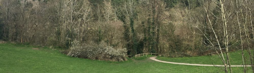


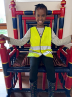

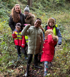
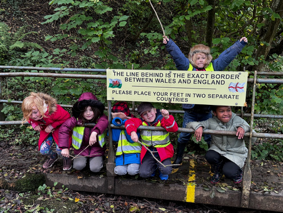

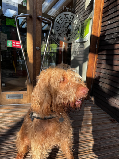

